Casillas geodata
Casillas (Santa Rosa) is a seat of a second-order administrative division; located in Guatemala in America/Guatemala (GMT-6) time zone. With population of 8,970 people, there are 142 cities with bigger population in this country. Compared to other cities in Guatemala, 87.3% of cities are located further ↑North; 74.9% of cities are located further ←West and 55.2% of cities have higher elevation than Casillas. Note1


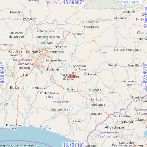
Casillas GPS coordinates[2]
14° 25' 8.94" North, 90° 14' 35.808" West
| Map corner | latitude | longitude |
|---|---|---|
| Upper-left | 15.09907°, | -90.94641° |
| Center: | 14.41915°, | -90.24328° |
| Lower-right: | 13.73715°, | -89.54016° |
| Map W x H: | 151.4×151.4 km | = 94.1×94.1mi |
| max Lat: | 17.06606° ⇑87.3% North |
| Casillas: | 14.41915° |
| min Lat: | ⇓12.7% South 13.9274° |
| min Long | Casillas | max Long |
| -92.19298° | -90.24328° | -88.59444° |
| W 74.9%⇐ | ⇒25.1% E |
Elevation
Elevation of Casillas is 1093 m = 3586 ft, and this is 174 m = 571 ft below average elevation for this country.
| Max E: |
3254 m = 10676 ft | 55.2% |
| Avg. | 1267 m = 4157 ft | |
| Casillas | 1093 m = 3586 ft | |
Min E: |
1 m = 3 ft | 44.8% |
See also: Guatemala elevation on elevation.city.
Geographical zone
Casillas is located in North Torrid zone (between Equator and Tropic of Cancer). Distance of this Northern Tropic circle is 1002.7 km =623 mi to North.| Distance of | km | miles | from Casillas |
|---|---|---|---|
| North Pole | 8403.8 | 5221.9 | to North |
| Arctic Circle | 5797.9 | 3602.6 | to North |
| Tropic Cancer | 1002.7 | 623 | to North |
| Equator | 1603.3 | 996.2 | to South |


Nearby cities:
15 places around Casillas: (largest is in red/bold)
• Barberena
17.8 km =11.1 mi,  225°
225°
• Cuilapa
17 km =10.6 mi,  200°
200°
• Fraijanes
21.9 km =13.6 mi,  283°
283°
• Mataquescuintla
13.8 km =8.6 mi,  27°
27°
• Nueva Santa Rosa
5.5 km =3.4 mi,  219°
219°
• Oratorio
22.5 km =14 mi,  161°
161°
• Palencia
30.2 km =18.8 mi,  336°
336°
• Quesada
27.4 km =17 mi,  127°
127°
• San Carlos Alzatate
21.6 km =13.4 mi,  66°
66°
• San José Acatempa
21.2 km =13.2 mi,  143°
143°
• San José Pinula
23.1 km =14.4 mi,  307°
307°
• San Rafael Las Flores
9.4 km =5.8 mi,  47°
47°
• Santa Cruz Naranjo
14 km =8.7 mi,  255°
255°
• Santa María Ixhuatán
25.7 km =16 mi,  187°
187°
• Santa Rosa de Lima
6.6 km =4.1 mi,  238°
238°
Sources, notices
• [Note1] Compared only with cities in Guatemala existing in our database
• [Src1] Map data: © OpenStreetMap contributors (CC-BY-SA)
• [Src2] Other city data from geonames.org with taken over terms of usage.
• [Src3] Geographical zone / Annual Mean Temperature by Robert A. Rohde @ Wikipedia
