Morazán geodata
Morazán (El Progreso) is a seat of a second-order administrative division; located in Guatemala in America/Guatemala (GMT-6) time zone. With population of 2,554 people, there are 259 cities with bigger population in this country. Compared to other cities in Guatemala, 60.8% of cities are located further ↓South; 77.9% of cities are located further ←West and 80.2% of cities have higher elevation than Morazán. Note1


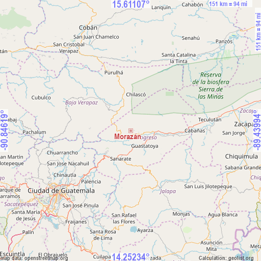
Morazán GPS coordinates[2]
14° 55' 58.008" North, 90° 8' 35.016" West
| Map corner | latitude | longitude |
|---|---|---|
| Upper-left | 15.61107°, | -90.84619° |
| Center: | 14.93278°, | -90.14306° |
| Lower-right: | 14.25234°, | -89.43994° |
| Map W x H: | 151.1×151.1 km | = 93.9×93.9mi |
| max Lat: | 17.06606° ⇑39.2% North |
| Morazán: | 14.93278° |
| min Lat: | ⇓60.8% South 13.9274° |
| min Long | Morazán | max Long |
| -92.19298° | -90.14306° | -88.59444° |
| W 77.9%⇐ | ⇒22.1% E |
Elevation
Elevation of Morazán is 359 m = 1178 ft, and this is 908 m = 2979 ft below average elevation for this country.
| Max E: |
3254 m = 10676 ft | 80.2% |
| Avg. | 1267 m = 4157 ft | |
| Morazán | 359 m = 1178 ft | |
Min E: |
1 m = 3 ft | 19.8% |
See also: Guatemala elevation on elevation.city.
Geographical zone
Morazán is located in North Torrid zone (between Equator and Tropic of Cancer). Distance of this Northern Tropic circle is 945.5 km =587.5 mi to North.| Distance of | km | miles | from Morazán |
|---|---|---|---|
| North Pole | 8346.7 | 5186.4 | to North |
| Arctic Circle | 5740.8 | 3567.2 | to North |
| Tropic Cancer | 945.5 | 587.5 | to North |
| Equator | 1660.4 | 1031.7 | to South |


Nearby cities:
15 places around Morazán: (largest is in red/bold)
• Cabañas
36.9 km =22.9 mi,  89°
89°
• El Chol
37.2 km =23.1 mi,  274°
274°
• El Jícaro
26.2 km =16.3 mi, 93°
• Guastatoya
11.8 km =7.3 mi,  137°
137°
• Jalapa
37.1 km =23.1 mi,  153°
153°
• Palencia
37.4 km =23.2 mi,  217°
217°
• Salamá
26.7 km =16.6 mi,  315°
315°
• San Agustín Acasaguastlán
19 km =11.8 mi,  84°
84°
• San Antonio La Paz
24.6 km =15.3 mi, 218°
• San Cristóbal Acasaguastlán
28 km =17.4 mi, 93°
• San Jerónimo
17.6 km =10.9 mi, 323°
• San José del Golfo
31 km =19.3 mi,  232°
232°
• San Miguel Chicaj
32.4 km =20.1 mi,  303°
303°
• Sanarate
17.1 km =10.6 mi,  200°
200°
• Sansare
21 km =13 mi,  172°
172°
Sources, notices
• [Note1] Compared only with cities in Guatemala existing in our database
• [Src1] Map data: © OpenStreetMap contributors (CC-BY-SA)
• [Src2] Other city data from geonames.org with taken over terms of usage.
• [Src3] Geographical zone / Annual Mean Temperature by Robert A. Rohde @ Wikipedia
