Sansare geodata
Sansare (El Progreso) is a seat of a second-order administrative division; located in Guatemala in America/Guatemala (GMT-6) time zone. With population of 3,792 people, there are 225 cities with bigger population in this country. Compared to other cities in Guatemala, 55.5% of cities are located further ↑North; 78.8% of cities are located further ←West and 65.5% of cities have higher elevation than Sansare. Note1


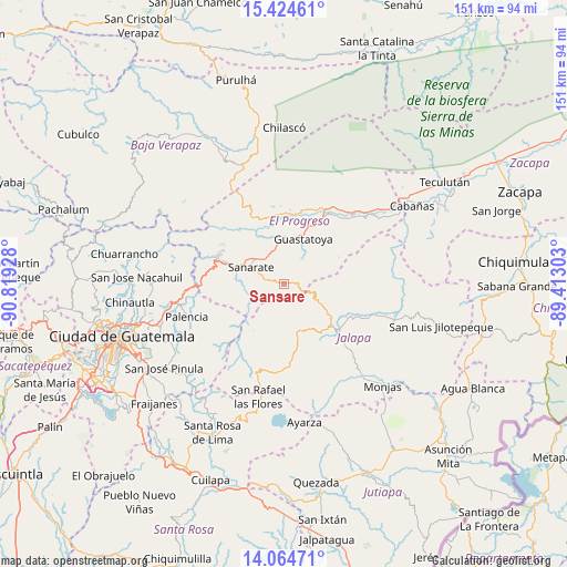
Sansare GPS coordinates[2]
14° 44' 44.592" North, 90° 6' 58.14" West
| Map corner | latitude | longitude |
|---|---|---|
| Upper-left | 15.42461°, | -90.81928° |
| Center: | 14.74572°, | -90.11615° |
| Lower-right: | 14.06471°, | -89.41303° |
| Map W x H: | 151.2×151.2 km | = 94×94mi |
| max Lat: | 17.06606° ⇑55.5% North |
| Sansare: | 14.74572° |
| min Lat: | ⇓44.5% South 13.9274° |
| min Long | Sansare | max Long |
| -92.19298° | -90.11615° | -88.59444° |
| W 78.8%⇐ | ⇒21.2% E |
Elevation
Elevation of Sansare is 790 m = 2592 ft, and this is 477 m = 1565 ft below average elevation for this country.
| Max E: |
3254 m = 10676 ft | 65.5% |
| Avg. | 1267 m = 4157 ft | |
| Sansare | 790 m = 2592 ft | |
Min E: |
1 m = 3 ft | 34.5% |
See also: Guatemala elevation on elevation.city.
Geographical zone
Sansare is located in North Torrid zone (between Equator and Tropic of Cancer). Distance of this Northern Tropic circle is 966.3 km =600.4 mi to North.| Distance of | km | miles | from Sansare |
|---|---|---|---|
| North Pole | 8367.5 | 5199.3 | to North |
| Arctic Circle | 5761.6 | 3580.1 | to North |
| Tropic Cancer | 966.3 | 600.4 | to North |
| Equator | 1639.6 | 1018.8 | to South |


Nearby cities:
15 places around Sansare: (largest is in red/bold)
• El Jícaro
30 km =18.6 mi,  50°
50°
• Guastatoya
13.1 km =8.1 mi,  22°
22°
• Jalapa
18.4 km =11.4 mi,  132°
132°
• Mataquescuintla
25.2 km =15.7 mi,  196°
196°
• Morazán
21 km =13 mi,  352°
352°
• Palencia
27.4 km =17 mi,  251°
251°
• San Agustín Acasaguastlán
27.8 km =17.3 mi,  35°
35°
• San Antonio La Paz
18.2 km =11.3 mi,  274°
274°
• San Carlos Alzatate
28.2 km =17.5 mi,  167°
167°
• San Cristóbal Acasaguastlán
31.4 km =19.5 mi, 52°
• San Diego
36 km =22.4 mi,  83°
83°
• San José del Golfo
27.6 km =17.1 mi, 274°
• San Pedro Pinula
29.9 km =18.6 mi,  107°
107°
• San Rafael Las Flores
30.7 km =19.1 mi,  192°
192°
• Sanarate
10.1 km =6.3 mi,  298°
298°
Sources, notices
• [Note1] Compared only with cities in Guatemala existing in our database
• [Src1] Map data: © OpenStreetMap contributors (CC-BY-SA)
• [Src2] Other city data from geonames.org with taken over terms of usage.
• [Src3] Geographical zone / Annual Mean Temperature by Robert A. Rohde @ Wikipedia
