Guastatoya geodata
Guastatoya (El Progreso) is a seat of a first-order administrative division; located in Guatemala in America/Guatemala (GMT-6) time zone. With population of 13,467 people, there are 92 cities with bigger population in this country. Compared to other cities in Guatemala, 53.7% of cities are located further ↓South; 79.4% of cities are located further ←West and 73.5% of cities have higher elevation than Guastatoya. Note1


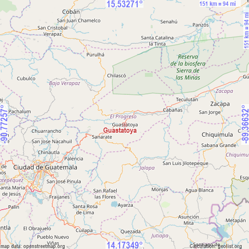
Guastatoya GPS coordinates[2]
14° 51' 15.012" North, 90° 4' 9.984" West
| Map corner | latitude | longitude |
|---|---|---|
| Upper-left | 15.53271°, | -90.77257° |
| Center: | 14.85417°, | -90.06944° |
| Lower-right: | 14.17349°, | -89.36632° |
| Map W x H: | 151.1×151.1 km | = 93.9×93.9mi |
| max Lat: | 17.06606° ⇑46.3% North |
| Guastatoya: | 14.85417° |
| min Lat: | ⇓53.7% South 13.9274° |
| min Long | Guastatoya | max Long |
| -92.19298° | -90.06944° | -88.59444° |
| W 79.4%⇐ | ⇒20.6% E |
Elevation
Elevation of Guastatoya is 520 m = 1706 ft, and this is 747 m = 2451 ft below average elevation for this country.
| Max E: |
3254 m = 10676 ft | 73.5% |
| Avg. | 1267 m = 4157 ft | |
| Guastatoya | 520 m = 1706 ft | |
Min E: |
1 m = 3 ft | 26.5% |
See also: Guatemala elevation on elevation.city.
Geographical zone
Guastatoya is located in North Torrid zone (between Equator and Tropic of Cancer). Distance of this Northern Tropic circle is 954.3 km =593 mi to North.| Distance of | km | miles | from Guastatoya |
|---|---|---|---|
| North Pole | 8355.4 | 5191.8 | to North |
| Arctic Circle | 5749.5 | 3572.6 | to North |
| Tropic Cancer | 954.3 | 593 | to North |
| Equator | 1651.6 | 1026.3 | to South |


Nearby cities:
15 places around Guastatoya: (largest is in red/bold)
• Cabañas
30.3 km =18.8 mi,  73°
73°
• El Jícaro
19.5 km =12.1 mi, 69°
• Jalapa
25.9 km =16.1 mi,  160°
160°
• Morazán
11.8 km =7.3 mi,  317°
317°
• Palencia
37.3 km =23.2 mi,  236°
236°
• San Agustín Acasaguastlán
15.3 km =9.5 mi,  46°
46°
• San Antonio La Paz
25.5 km =15.8 mi,  245°
245°
• San Cristóbal Acasaguastlán
21.2 km =13.2 mi, 70°
• San Diego
31.7 km =19.7 mi,  104°
104°
• San Jerónimo
29.4 km =18.3 mi, 321°
• San José del Golfo
34.1 km =21.2 mi, 252°
• San Pedro Pinula
31.5 km =19.6 mi,  131°
131°
• Sanarate
15.7 km =9.8 mi, 242°
• Sansare
13.1 km =8.1 mi,  202°
202°
• Usumatlán
32.5 km =20.2 mi, 70°
Sources, notices
• [Note1] Compared only with cities in Guatemala existing in our database
• [Src1] Map data: © OpenStreetMap contributors (CC-BY-SA)
• [Src2] Other city data from geonames.org with taken over terms of usage.
• [Src3] Geographical zone / Annual Mean Temperature by Robert A. Rohde @ Wikipedia
