San José del Golfo geodata
San José del Golfo (Guatemala) is a seat of a second-order administrative division; located in Guatemala in America/Guatemala (GMT-6) time zone. With population of 4,908 people, there are 206 cities with bigger population in this country. Compared to other cities in Guatemala, 54.6% of cities are located further ↑North; 70.2% of cities are located further ←West and 62.8% of cities have higher elevation than San José del Golfo. Note1


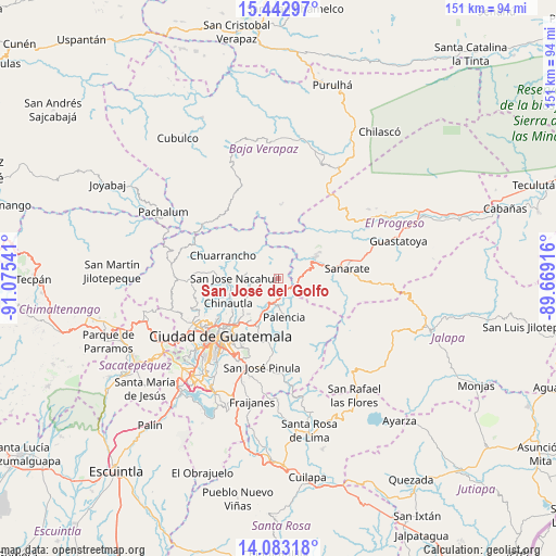
San José del Golfo GPS coordinates[2]
14° 45' 50.904" North, 90° 22' 20.208" West
| Map corner | latitude | longitude |
|---|---|---|
| Upper-left | 15.44297°, | -91.07541° |
| Center: | 14.76414°, | -90.37228° |
| Lower-right: | 14.08318°, | -89.66916° |
| Map W x H: | 151.2×151.2 km | = 94×94mi |
| max Lat: | 17.06606° ⇑54.6% North |
| San José del Golfo: | 14.76414° |
| min Lat: | ⇓45.4% South 13.9274° |
| min Long | San José del G | max Long |
| -92.19298° | -90.37228° | -88.59444° |
| W 70.2%⇐ | ⇒29.8% E |
Elevation
Elevation of San José del Golfo is 902 m = 2959 ft, and this is 365 m = 1198 ft below average elevation for this country.
| Max E: |
3254 m = 10676 ft | 62.8% |
| Avg. | 1267 m = 4157 ft | |
| San José del Golfo | 902 m = 2959 ft | |
Min E: |
1 m = 3 ft | 37.2% |
See also: Guatemala elevation on elevation.city.
Geographical zone
San José del Golfo is located in North Torrid zone (between Equator and Tropic of Cancer). Distance of this Northern Tropic circle is 964.3 km =599.2 mi to North.| Distance of | km | miles | from San José del Golfo |
|---|---|---|---|
| North Pole | 8365.4 | 5198 | to North |
| Arctic Circle | 5759.6 | 3578.8 | to North |
| Tropic Cancer | 964.3 | 599.2 | to North |
| Equator | 1641.6 | 1020 | to South |


Nearby cities:
15 places around San José del Golfo: (largest is in red/bold)
• Chinautla
15.3 km =9.5 mi,  243°
243°
• Chuarrancho
16.5 km =10.3 mi,  291°
291°
• El Chol
25.1 km =15.6 mi,  330°
330°
• Granados
23.4 km =14.5 mi,  316°
316°
• Guatemala City
20.5 km =12.7 mi,  227°
227°
• Mixco
29.3 km =18.2 mi, 239°
• Palencia
10.9 km =6.8 mi,  171°
171°
• San Antonio La Paz
9.4 km =5.8 mi,  93°
93°
• San José Pinula
24.6 km =15.3 mi,  190°
190°
• San Juan Sacatepéquez
29.7 km =18.5 mi,  260°
260°
• San Pedro Ayampuc
8.9 km =5.5 mi,  281°
281°
• San Raimundo
23.9 km =14.9 mi,  270°
270°
• Sanarate
18.8 km =11.7 mi,  81°
81°
• Sansare
27.6 km =17.1 mi, 94°
• Santa Catarina Pinula
25.5 km =15.8 mi,  212°
212°
Sources, notices
• [Note1] Compared only with cities in Guatemala existing in our database
• [Src1] Map data: © OpenStreetMap contributors (CC-BY-SA)
• [Src2] Other city data from geonames.org with taken over terms of usage.
• [Src3] Geographical zone / Annual Mean Temperature by Robert A. Rohde @ Wikipedia
