Sanarate geodata
Sanarate (El Progreso) is a seat of a second-order administrative division; located in Guatemala in America/Guatemala (GMT-6) time zone. With population of 15,843 people, there are 75 cities with bigger population in this country. Compared to other cities in Guatemala, 51% of cities are located further ↑North; 76.4% of cities are located further ←West and 64.9% of cities have higher elevation than Sanarate. Note1


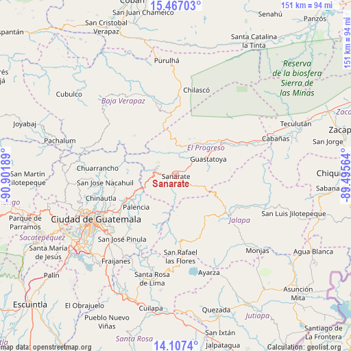
Sanarate GPS coordinates[2]
14° 47' 17.808" North, 90° 11' 55.536" West
| Map corner | latitude | longitude |
|---|---|---|
| Upper-left | 15.46703°, | -90.90189° |
| Center: | 14.78828°, | -90.19876° |
| Lower-right: | 14.1074°, | -89.49564° |
| Map W x H: | 151.2×151.2 km | = 94×94mi |
| max Lat: | 17.06606° ⇑51% North |
| Sanarate: | 14.78828° |
| min Lat: | ⇓49% South 13.9274° |
| min Long | Sanarate | max Long |
| -92.19298° | -90.19876° | -88.59444° |
| W 76.4%⇐ | ⇒23.6% E |
Elevation
Elevation of Sanarate is 840 m = 2756 ft, and this is 427 m = 1401 ft below average elevation for this country.
| Max E: |
3254 m = 10676 ft | 64.9% |
| Avg. | 1267 m = 4157 ft | |
| Sanarate | 840 m = 2756 ft | |
Min E: |
1 m = 3 ft | 35.1% |
See also: Guatemala elevation on elevation.city.
Geographical zone
Sanarate is located in North Torrid zone (between Equator and Tropic of Cancer). Distance of this Northern Tropic circle is 961.6 km =597.5 mi to North.| Distance of | km | miles | from Sanarate |
|---|---|---|---|
| North Pole | 8362.8 | 5196.4 | to North |
| Arctic Circle | 5756.9 | 3577.2 | to North |
| Tropic Cancer | 961.6 | 597.5 | to North |
| Equator | 1644.3 | 1021.7 | to South |


Nearby cities:
15 places around Sanarate: (largest is in red/bold)
• Chinautla
33.7 km =20.9 mi,  253°
253°
• Chuarrancho
34.2 km =21.3 mi,  275°
275°
• El Jícaro
35.1 km =21.8 mi,  66°
66°
• Guastatoya
15.7 km =9.8 mi,  62°
62°
• Jalapa
28.3 km =17.6 mi,  127°
127°
• Mataquescuintla
28.9 km =18 mi,  176°
176°
• Morazán
17.1 km =10.6 mi,  20°
20°
• Palencia
21.7 km =13.5 mi,  231°
231°
• San Agustín Acasaguastlán
30.7 km =19.1 mi,  54°
54°
• San Antonio La Paz
9.8 km =6.1 mi, 250°
• San Jerónimo
30.6 km =19 mi,  351°
351°
• San José del Golfo
18.8 km =11.7 mi,  261°
261°
• San Pedro Ayampuc
27.4 km =17 mi,  267°
267°
• San Rafael Las Flores
34.8 km =21.6 mi, 176°
• Sansare
10.1 km =6.3 mi,  118°
118°
Sources, notices
• [Note1] Compared only with cities in Guatemala existing in our database
• [Src1] Map data: © OpenStreetMap contributors (CC-BY-SA)
• [Src2] Other city data from geonames.org with taken over terms of usage.
• [Src3] Geographical zone / Annual Mean Temperature by Robert A. Rohde @ Wikipedia
