La Democracia geodata
La Democracia (Huehuetenango) is a seat of a second-order administrative division; located in Guatemala in America/Guatemala (GMT-6) time zone. In our database, there are 325 cities with bigger population. Compared to other cities in Guatemala, 90.3% of cities are located further ↓South; 94.1% of cities are located further →East and 61.7% of cities have higher elevation than La Democracia. Note1


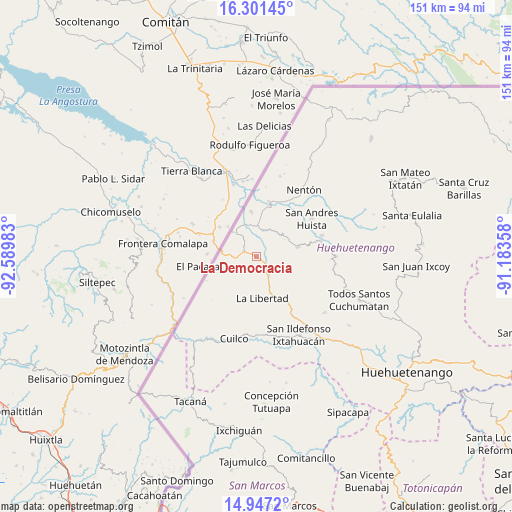
La Democracia GPS coordinates[2]
15° 37' 31.584" North, 91° 53' 12.12" West
| Map corner | latitude | longitude |
|---|---|---|
| Upper-left | 16.30145°, | -92.58983° |
| Center: | 15.62544°, | -91.8867° |
| Lower-right: | 14.9472°, | -91.18358° |
| Map W x H: | 150.6×150.6 km | = 93.6×93.6mi |
| max Lat: | 17.06606° ⇑9.7% North |
| La Democracia: | 15.62544° |
| min Lat: | ⇓90.3% South 13.9274° |
| min Long | La Democracia | max Long |
| -92.19298° | -91.8867° | -88.59444° |
| W 5.9%⇐ | ⇒94.1% E |
Elevation
Elevation of La Democracia is 928 m = 3045 ft, and this is 339 m = 1112 ft below average elevation for this country.
| Max E: |
3254 m = 10676 ft | 61.7% |
| Avg. | 1267 m = 4157 ft | |
| La Democracia | 928 m = 3045 ft | |
Min E: |
1 m = 3 ft | 38.3% |
See also: Guatemala elevation on elevation.city.
Geographical zone
La Democracia is located in North Torrid zone (between Equator and Tropic of Cancer). Distance of this Northern Tropic circle is 868.5 km =539.7 mi to North.| Distance of | km | miles | from La Democracia |
|---|---|---|---|
| North Pole | 8269.7 | 5138.6 | to North |
| Arctic Circle | 5663.8 | 3519.3 | to North |
| Tropic Cancer | 868.5 | 539.7 | to North |
| Equator | 1737.4 | 1079.6 | to South |


Nearby cities:
15 places around La Democracia: (largest is in red/bold)
• Colotenango
30.7 km =19.1 mi,  142°
142°
• Concepción Huista
23.7 km =14.7 mi,  90°
90°
• Cuilco
25.1 km =15.6 mi,  194°
194°
• Ixtahuacán
26.4 km =16.4 mi,  151°
151°
• Jacaltenango
19.3 km =12 mi,  76°
76°
• La Libertad
12.5 km =7.8 mi,  171°
171°
• Nentón
24.1 km =15 mi,  35°
35°
• San Antonio Huista
12.6 km =7.8 mi, 77°
• San Gaspar Ixchil
31.5 km =19.6 mi, 146°
• San Miguel Acatán
32.1 km =19.9 mi,  74°
74°
• San Pedro Necta
19.8 km =12.3 mi, 138°
• San Rafael Petzal
34.2 km =21.3 mi, 135°
• Santa Ana Huista
9.4 km =5.8 mi,  49°
49°
• Santiago Chimaltenango
26.2 km =16.3 mi,  129°
129°
• Todos Santos Cuchumatán
33 km =20.5 mi,  113°
113°
Sources, notices
• [Note1] Compared only with cities in Guatemala existing in our database
• [Src1] Map data: © OpenStreetMap contributors (CC-BY-SA)
• [Src2] Other city data from geonames.org with taken over terms of usage.
• [Src3] Geographical zone / Annual Mean Temperature by Robert A. Rohde @ Wikipedia
