San Rafael Petzal geodata
San Rafael Petzal (Huehuetenango) is a seat of a second-order administrative division; located in Guatemala in America/Guatemala (GMT-6) time zone. With population of 1,525 people, there are 296 cities with bigger population in this country. Compared to other cities in Guatemala, 84.1% of cities are located further ↓South; 83.8% of cities are located further →East and 67.6% of cities have lower elevation than San Rafael Petzal. Note1


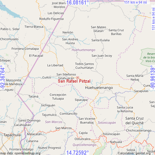
San Rafael Petzal GPS coordinates[2]
15° 24' 17.532" North, 91° 39' 52.236" West
| Map corner | latitude | longitude |
|---|---|---|
| Upper-left | 16.08161°, | -92.36764° |
| Center: | 15.40487°, | -91.66451° |
| Lower-right: | 14.72592°, | -90.96139° |
| Map W x H: | 150.7×150.7 km | = 93.6×93.6mi |
| max Lat: | 17.06606° ⇑15.9% North |
| San Rafael Petzal: | 15.40487° |
| min Lat: | ⇓84.1% South 13.9274° |
| min Long | San Rafael Petz | max Long |
| -92.19298° | -91.66451° | -88.59444° |
| W 16.2%⇐ | ⇒83.8% E |
Elevation
Elevation of San Rafael Petzal is 1738 m = 5702 ft, and this is 471 m = 1545 ft above average elevation for this country.
| Max E: |
3254 m = 10676 ft | 32.4% |
| San Rafael Petzal | 1738 m 5702 ft | |
| Avg. | 1267 m = 4157 ft | |
Min E: |
1 m = 3 ft | 67.6% |
See also: Guatemala elevation on elevation.city.
Geographical zone
San Rafael Petzal is located in North Torrid zone (between Equator and Tropic of Cancer). Distance of this Northern Tropic circle is 893.1 km =554.9 mi to North.| Distance of | km | miles | from San Rafael Petzal |
|---|---|---|---|
| North Pole | 8294.2 | 5153.8 | to North |
| Arctic Circle | 5688.3 | 3534.5 | to North |
| Tropic Cancer | 893.1 | 554.9 | to North |
| Equator | 1712.9 | 1064.3 | to South |


Nearby cities:
15 places around San Rafael Petzal: (largest is in red/bold)
• Chiantla
22.8 km =14.2 mi,  104°
104°
• Colotenango
5.2 km =3.2 mi,  271°
271°
• Concepción Huista
24.3 km =15.1 mi,  359°
359°
• Huehuetenango
22.7 km =14.1 mi,  114°
114°
• Ixtahuacán
11.3 km =7 mi,  276°
276°
• La Libertad
25.1 km =15.6 mi,  298°
298°
• San Gaspar Ixchil
6.8 km =4.2 mi,  253°
253°
• San Juan Atitán
5.1 km =3.2 mi,  58°
58°
• San Miguel Ixtahuacán
17.2 km =10.7 mi,  211°
211°
• San Pedro Necta
14.5 km =9 mi,  311°
311°
• San Sebastián Huehuetenango
5.6 km =3.5 mi, 109°
• Santa Bárbara
10.4 km =6.5 mi,  160°
160°
• Santiago Chimaltenango
8.7 km =5.4 mi,  336°
336°
• Sipacapa
21.6 km =13.4 mi,  171°
171°
• Todos Santos Cuchumatán
13.2 km =8.2 mi,  29°
29°
Sources, notices
• [Note1] Compared only with cities in Guatemala existing in our database
• [Src1] Map data: © OpenStreetMap contributors (CC-BY-SA)
• [Src2] Other city data from geonames.org with taken over terms of usage.
• [Src3] Geographical zone / Annual Mean Temperature by Robert A. Rohde @ Wikipedia
