Concepción Huista geodata
Concepción Huista (Huehuetenango) is a seat of a second-order administrative division; located in Guatemala in America/Guatemala (GMT-6) time zone. With population of 8,925 people, there are 145 cities with bigger population in this country. Compared to other cities in Guatemala, 90% of cities are located further ↓South; 84.1% of cities are located further →East and 84.7% of cities have lower elevation than Concepción Huista. Note1


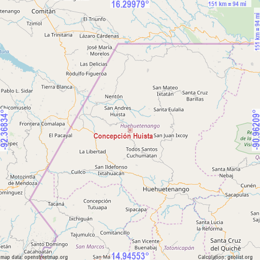
Concepción Huista GPS coordinates[2]
15° 37' 25.608" North, 91° 39' 54.756" West
| Map corner | latitude | longitude |
|---|---|---|
| Upper-left | 16.29979°, | -92.36834° |
| Center: | 15.62378°, | -91.66521° |
| Lower-right: | 14.94553°, | -90.96209° |
| Map W x H: | 150.6×150.6 km | = 93.6×93.6mi |
| max Lat: | 17.06606° ⇑10% North |
| Concepción Huista: | 15.62378° |
| min Lat: | ⇓90% South 13.9274° |
| min Long | Concepción Hui | max Long |
| -92.19298° | -91.66521° | -88.59444° |
| W 15.9%⇐ | ⇒84.1% E |
Elevation
Elevation of Concepción Huista is 2238 m = 7343 ft, and this is 971 m = 3186 ft above average elevation for this country.
| Max E: |
3254 m = 10676 ft | 15.3% |
| Concepción Huista | 2238 m 7343 ft | |
| Avg. | 1267 m = 4157 ft | |
Min E: |
1 m = 3 ft | 84.7% |
See also: Guatemala elevation on elevation.city.
Geographical zone
Concepción Huista is located in North Torrid zone (between Equator and Tropic of Cancer). Distance of this Northern Tropic circle is 868.7 km =539.8 mi to North.| Distance of | km | miles | from Concepción Huista |
|---|---|---|---|
| North Pole | 8269.9 | 5138.7 | to North |
| Arctic Circle | 5664 | 3519.4 | to North |
| Tropic Cancer | 868.7 | 539.8 | to North |
| Equator | 1737.2 | 1079.4 | to South |


Nearby cities:
15 places around Concepción Huista: (largest is in red/bold)
• Colotenango
24.7 km =15.3 mi,  191°
191°
• Jacaltenango
6.9 km =4.3 mi,  313°
313°
• La Democracia
23.7 km =14.7 mi,  270°
270°
• Nentón
21.9 km =13.6 mi,  334°
334°
• San Antonio Huista
11.8 km =7.3 mi,  284°
284°
• San Juan Atitán
22.1 km =13.7 mi,  168°
168°
• San Juan Ixcoy
23.6 km =14.7 mi,  96°
96°
• San Miguel Acatán
11.5 km =7.1 mi,  39°
39°
• San Pedro Necta
18.2 km =11.3 mi,  216°
216°
• San Rafael La Independencia
16.4 km =10.2 mi,  58°
58°
• San Rafael Petzal
24.3 km =15.1 mi,  179°
179°
• San Sebastián Coatán
16.6 km =10.3 mi, 41°
• Santa Ana Huista
17.8 km =11.1 mi,  290°
290°
• Santiago Chimaltenango
16.7 km =10.4 mi, 191°
• Todos Santos Cuchumatán
14.4 km =8.9 mi,  152°
152°
Sources, notices
• [Note1] Compared only with cities in Guatemala existing in our database
• [Src1] Map data: © OpenStreetMap contributors (CC-BY-SA)
• [Src2] Other city data from geonames.org with taken over terms of usage.
• [Src3] Geographical zone / Annual Mean Temperature by Robert A. Rohde @ Wikipedia
