San Antonio Huista geodata
San Antonio Huista (Huehuetenango) is a seat of a second-order administrative division; located in Guatemala in America/Guatemala (GMT-6) time zone. With population of 5,669 people, there are 192 cities with bigger population in this country. Compared to other cities in Guatemala, 90.6% of cities are located further ↓South; 90% of cities are located further →East and 50.7% of cities have higher elevation than San Antonio Huista. Note1


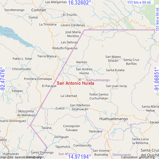
San Antonio Huista GPS coordinates[2]
15° 39' 0.36" North, 91° 46' 17.868" West
| Map corner | latitude | longitude |
|---|---|---|
| Upper-left | 16.32602°, | -92.47476° |
| Center: | 15.6501°, | -91.77163° |
| Lower-right: | 14.97194°, | -91.06851° |
| Map W x H: | 150.6×150.6 km | = 93.6×93.6mi |
| max Lat: | 17.06606° ⇑9.4% North |
| San Antonio Huista: | 15.6501° |
| min Lat: | ⇓90.6% South 13.9274° |
| min Long | San Antonio Hui | max Long |
| -92.19298° | -91.77163° | -88.59444° |
| W 10%⇐ | ⇒90% E |
Elevation
Elevation of San Antonio Huista is 1243 m = 4078 ft, and this is 24 m = 79 ft below average elevation for this country.
| Max E: |
3254 m = 10676 ft | 50.7% |
| Avg. | 1267 m = 4157 ft | |
| San Antonio Huista | 1243 m = 4078 ft | |
Min E: |
1 m = 3 ft | 49.3% |
See also: Guatemala elevation on elevation.city.
Geographical zone
San Antonio Huista is located in North Torrid zone (between Equator and Tropic of Cancer). Distance of this Northern Tropic circle is 865.8 km =538 mi to North.| Distance of | km | miles | from San Antonio Huista |
|---|---|---|---|
| North Pole | 8266.9 | 5136.8 | to North |
| Arctic Circle | 5661 | 3517.6 | to North |
| Tropic Cancer | 865.8 | 538 | to North |
| Equator | 1740.1 | 1081.2 | to South |


Nearby cities:
15 places around San Antonio Huista: (largest is in red/bold)
• Colotenango
27.9 km =17.3 mi,  166°
166°
• Concepción Huista
11.8 km =7.3 mi,  104°
104°
• Ixtahuacán
25.9 km =16.1 mi,  179°
179°
• Jacaltenango
6.7 km =4.2 mi,  74°
74°
• La Democracia
12.6 km =7.8 mi,  257°
257°
• La Libertad
18.4 km =11.4 mi,  214°
214°
• Nentón
16.8 km =10.4 mi,  6°
6°
• San Juan Atitán
29.2 km =18.1 mi,  147°
147°
• San Miguel Acatán
19.6 km =12.2 mi, 72°
• San Pedro Necta
17.7 km =11 mi, 177°
• San Rafael La Independencia
25.9 km =16.1 mi,  77°
77°
• San Sebastián Coatán
24.3 km =15.1 mi, 66°
• Santa Ana Huista
6.2 km =3.9 mi,  303°
303°
• Santiago Chimaltenango
20.9 km =13 mi,  157°
157°
• Todos Santos Cuchumatán
23.9 km =14.9 mi,  131°
131°
Sources, notices
• [Note1] Compared only with cities in Guatemala existing in our database
• [Src1] Map data: © OpenStreetMap contributors (CC-BY-SA)
• [Src2] Other city data from geonames.org with taken over terms of usage.
• [Src3] Geographical zone / Annual Mean Temperature by Robert A. Rohde @ Wikipedia
