Todos Santos Cuchumatán geodata
Todos Santos Cuchumatán (Huehuetenango) is a seat of a second-order administrative division; located in Guatemala in America/Guatemala (GMT-6) time zone. With population of 3,289 people, there are 238 cities with bigger population in this country. Compared to other cities in Guatemala, 88.2% of cities are located further ↓South; 79.1% of cities are located further →East and 93.2% of cities have lower elevation than Todos Santos Cuchumatán. Note1
Current local time in Todos Santos Cuchumatán:
03:48 PM, SundayDifference from your time zone: hours


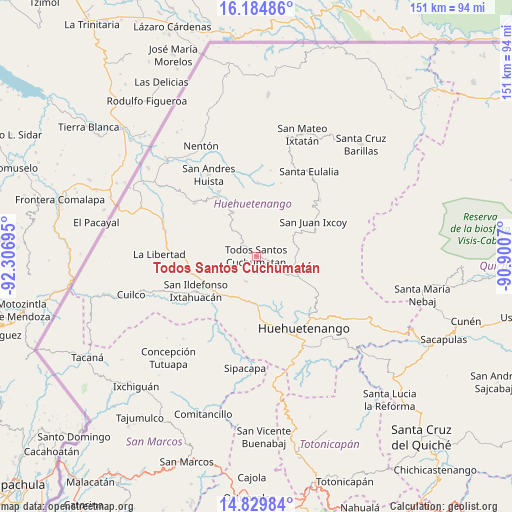
Todos Santos Cuchumatán GPS coordinates[2]
15° 30' 30.456" North, 91° 36' 13.752" West
| Map corner | latitude | longitude |
|---|---|---|
| Upper-left | 16.18486°, | -92.30695° |
| Center: | 15.50846°, | -91.60382° |
| Lower-right: | 14.82984°, | -90.9007° |
| Map W x H: | 150.7×150.7 km | = 93.6×93.6mi |
| max Lat: | 17.06606° ⇑11.8% North |
| Todos Santos Cuchumatán: | 15.50846° |
| min Lat: | ⇓88.2% South 13.9274° |
| min Long | Todos Santos Cu | max Long |
| -92.19298° | -91.60382° | -88.59444° |
| W 20.9%⇐ | ⇒79.1% E |
Elevation
Elevation of Todos Santos Cuchumatán is 2500 m = 8202 ft, and this is 1233 m = 4045 ft above average elevation for this country.
| Max E: |
3254 m = 10676 ft | 6.8% |
| Todos Santos Cuchumatán | 2500 m 8202 ft | |
| Avg. | 1267 m = 4157 ft | |
Min E: |
1 m = 3 ft | 93.2% |
See also: Guatemala elevation on elevation.city.
Geographical zone
Todos Santos Cuchumatán is located in North Torrid zone (between Equator and Tropic of Cancer). Distance of this Northern Tropic circle is 881.5 km =547.7 mi to North.| Distance of | km | miles | from Todos Santos Cuchumatán |
|---|---|---|---|
| North Pole | 8282.7 | 5146.6 | to North |
| Arctic Circle | 5676.8 | 3527.4 | to North |
| Tropic Cancer | 881.5 | 547.7 | to North |
| Equator | 1724.4 | 1071.5 | to South |


Nearby cities:
15 places around Todos Santos Cuchumatán: (largest is in red/bold)
• Chiantla
23.1 km =14.4 mi,  137°
137°
• Colotenango
16.3 km =10.1 mi,  225°
225°
• Concepción Huista
14.4 km =8.9 mi,  332°
332°
• Ixtahuacán
20.4 km =12.7 mi,  240°
240°
• Jacaltenango
21 km =13 mi, 326°
• San Gaspar Ixchil
18.7 km =11.6 mi,  224°
224°
• San Juan Atitán
9.1 km =5.7 mi,  193°
193°
• San Juan Ixcoy
19.7 km =12.2 mi,  58°
58°
• San Miguel Acatán
21.8 km =13.5 mi,  1°
1°
• San Pedro Necta
17.4 km =10.8 mi,  263°
263°
• San Rafael La Independencia
22.7 km =14.1 mi,  18°
18°
• San Rafael Petzal
13.2 km =8.2 mi,  209°
209°
• San Sebastián Huehuetenango
13.5 km =8.4 mi, 185°
• Santa Bárbara
21.6 km =13.4 mi, 188°
• Santiago Chimaltenango
10.6 km =6.6 mi,  250°
250°
Sources, notices
• [Note1] Compared only with cities in Guatemala existing in our database
• [Src1] Map data: © OpenStreetMap contributors (CC-BY-SA)
• [Src2] Other city data from geonames.org with taken over terms of usage.
• [Src3] Geographical zone / Annual Mean Temperature by Robert A. Rohde @ Wikipedia
