Nentón geodata
Nentón (Huehuetenango) is a seat of a second-order administrative division; located in Guatemala in America/Guatemala (GMT-6) time zone. With population of 2,530 people, there are 261 cities with bigger population in this country. Compared to other cities in Guatemala, 93.8% of cities are located further ↓South; 88.8% of cities are located further →East and 66.4% of cities have higher elevation than Nentón. Note1


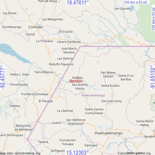
Nentón GPS coordinates[2]
15° 48' 2.52" North, 91° 45' 16.704" West
| Map corner | latitude | longitude |
|---|---|---|
| Upper-left | 16.47611°, | -92.45777° |
| Center: | 15.8007°, | -91.75464° |
| Lower-right: | 15.12303°, | -91.05152° |
| Map W x H: | 150.4×150.5 km | = 93.5×93.5mi |
| max Lat: | 17.06606° ⇑6.2% North |
| Nentón: | 15.8007° |
| min Lat: | ⇓93.8% South 13.9274° |
| min Long | Nentón | max Long |
| -92.19298° | -91.75464° | -88.59444° |
| W 11.2%⇐ | ⇒88.8% E |
Elevation
Elevation of Nentón is 775 m = 2543 ft, and this is 492 m = 1614 ft below average elevation for this country.
| Max E: |
3254 m = 10676 ft | 66.4% |
| Avg. | 1267 m = 4157 ft | |
| Nentón | 775 m = 2543 ft | |
Min E: |
1 m = 3 ft | 33.6% |
See also: Guatemala elevation on elevation.city.
Geographical zone
Nentón is located in North Torrid zone (between Equator and Tropic of Cancer). Distance of this Northern Tropic circle is 849 km =527.5 mi to North.| Distance of | km | miles | from Nentón |
|---|---|---|---|
| North Pole | 8250.2 | 5126.4 | to North |
| Arctic Circle | 5644.3 | 3507.2 | to North |
| Tropic Cancer | 849 | 527.5 | to North |
| Equator | 1756.9 | 1091.7 | to South |


Nearby cities:
15 places around Nentón: (largest is in red/bold)
• Concepción Huista
21.9 km =13.6 mi,  154°
154°
• Jacaltenango
15.6 km =9.7 mi,  162°
162°
• La Democracia
24.1 km =15 mi,  215°
215°
• La Libertad
34.1 km =21.2 mi,  201°
201°
• San Antonio Huista
16.8 km =10.4 mi,  186°
186°
• San Mateo Ixtatán
29.8 km =18.5 mi,  83°
83°
• San Miguel Acatán
19.9 km =12.4 mi,  122°
122°
• San Pedro Necta
34.4 km =21.4 mi,  181°
181°
• San Rafael La Independencia
25.9 km =16.1 mi, 115°
• San Sebastián Coatán
21.8 km =13.5 mi,  109°
109°
• Santa Ana Huista
15.1 km =9.4 mi,  207°
207°
• Santa Eulalia
32.6 km =20.3 mi,  103°
103°
• Santiago Chimaltenango
36.6 km =22.7 mi,  170°
170°
• Todos Santos Cuchumatán
36.3 km =22.6 mi, 153°
• Unión
13.7 km =8.5 mi,  350°
350°
Sources, notices
• [Note1] Compared only with cities in Guatemala existing in our database
• [Src1] Map data: © OpenStreetMap contributors (CC-BY-SA)
• [Src2] Other city data from geonames.org with taken over terms of usage.
• [Src3] Geographical zone / Annual Mean Temperature by Robert A. Rohde @ Wikipedia
