Río Bravo geodata
Río Bravo (Suchitepeque) is a populated place; located in Guatemala in America/Guatemala (GMT-6) time zone. With population of 7,568 people, there are 163 cities with bigger population in this country. Compared to other cities in Guatemala, 88.2% of cities are located further ↑North; 64% of cities are located further →East and 92% of cities have higher elevation than Río Bravo. Note1


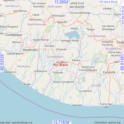
Río Bravo GPS coordinates[2]
14° 24' 1.512" North, 91° 19' 1.668" West
| Map corner | latitude | longitude |
|---|---|---|
| Upper-left | 15.0804°, | -92.02026° |
| Center: | 14.40042°, | -91.31713° |
| Lower-right: | 13.71836°, | -90.61401° |
| Map W x H: | 151.4×151.4 km | = 94.1×94.1mi |
| max Lat: | 17.06606° ⇑88.2% North |
| Río Bravo: | 14.40042° |
| min Lat: | ⇓11.8% South 13.9274° |
| min Long | Río Bravo | max Long |
| -92.19298° | -91.31713° | -88.59444° |
| W 36%⇐ | ⇒64% E |
Elevation
Elevation of Río Bravo is 161 m = 528 ft, and this is 1106 m = 3629 ft below average elevation for this country.
| Max E: |
3254 m = 10676 ft | 92% |
| Avg. | 1267 m = 4157 ft | |
| Río Bravo | 161 m = 528 ft | |
Min E: |
1 m = 3 ft | 8% |
See also: Guatemala elevation on elevation.city.
Geographical zone
Río Bravo is located in North Torrid zone (between Equator and Tropic of Cancer). Distance of this Northern Tropic circle is 1004.7 km =624.3 mi to North.| Distance of | km | miles | from Río Bravo |
|---|---|---|---|
| North Pole | 8405.9 | 5223.2 | to North |
| Arctic Circle | 5800 | 3604 | to North |
| Tropic Cancer | 1004.7 | 624.3 | to North |
| Equator | 1601.2 | 994.9 | to South |


Nearby cities:
15 places around Río Bravo: (largest is in red/bold)
• Chicacao
15.9 km =9.9 mi,  356°
356°
• Mazatenango
25 km =15.5 mi,  306°
306°
• Nueva Concepción
22.4 km =13.9 mi,  175°
175°
• Patulul
17.1 km =10.6 mi,  81°
81°
• Samayac
25.4 km =15.8 mi,  322°
322°
• San Antonio Suchitepéquez
18.7 km =11.6 mi,  325°
325°
• San Bernardino
21.9 km =13.6 mi, 316°
• San Gabriel
23.9 km =14.9 mi,  300°
300°
• San José El Ídolo
12.6 km =7.8 mi, 296°
• San Juan Bautista
15.1 km =9.4 mi, 80°
• San Lorenzo
23.1 km =14.4 mi,  294°
294°
• San Miguel Panán
15.2 km =9.4 mi,  339°
339°
• Santa Bárbara
10.5 km =6.5 mi,  68°
68°
• Santo Domingo Suchitepéquez
19.9 km =12.4 mi, 296°
• Tiquisate
13.8 km =8.6 mi,  199°
199°
Sources, notices
• [Note1] Compared only with cities in Guatemala existing in our database
• [Src1] Map data: © OpenStreetMap contributors (CC-BY-SA)
• [Src2] Other city data from geonames.org with taken over terms of usage.
• [Src3] Geographical zone / Annual Mean Temperature by Robert A. Rohde @ Wikipedia
