Wawina geodata
Wawina (Gracias a Dios) is a populated place; located in Honduras in America/Tegucigalpa (GMT-6) time zone. With population of 1,481 people, there are 244 cities with bigger population in this country. Compared to other cities in Honduras, 80.2% of cities are located further ↓South; 98.2% of cities are located further ←West and 92.4% of cities have higher elevation than Wawina. Note1


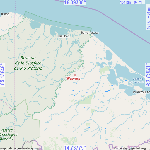
Wawina GPS coordinates[2]
15° 25' 0.012" North, 84° 25' 59.988" West
| Map corner | latitude | longitude |
|---|---|---|
| Upper-left | 16.09338°, | -85.13646° |
| Center: | 15.41667°, | -84.43333° |
| Lower-right: | 14.73775°, | -83.73021° |
| Map W x H: | 150.7×150.7 km | = 93.6×93.6mi |
| max Lat: | 16.45° ⇑19.8% North |
| Wawina: | 15.41667° |
| min Lat: | ⇓80.2% South 13.11667° |
| min Long | Wawina | max Long |
| -89.23333° | -84.43333° | -83.23333° |
| W 98.2%⇐ | ⇒1.8% E |
Elevation
Elevation of Wawina is 17 m = 56 ft, and this is 544.2 m = 1785 ft below average elevation for this country.
| Max E: |
1811 m = 5942 ft | 92.4% |
| Avg. | 561.2 m = 1841 ft | |
| Wawina | 17 m = 56 ft | |
Min E: |
1 m = 3 ft | 7.6% |
See also: Honduras elevation on elevation.city.
Geographical zone
Wawina is located in North Torrid zone (between Equator and Tropic of Cancer). Distance of this Northern Tropic circle is 891.7 km =554.1 mi to North.| Distance of | km | miles | from Wawina |
|---|---|---|---|
| North Pole | 8292.9 | 5153 | to North |
| Arctic Circle | 5687 | 3533.7 | to North |
| Tropic Cancer | 891.7 | 554.1 | to North |
| Equator | 1714.2 | 1065.2 | to South |


Nearby cities:
15 places around Wawina: (largest is in red/bold)
• Auas
13 km =8.1 mi,  55°
55°
• Auka
83.4 km =51.8 mi,  129°
129°
• Barra Patuca
45.5 km =28.3 mi,  20°
20°
• Bonito Oriental
144.2 km =89.6 mi,  284°
284°
• Brus Laguna
37.4 km =23.2 mi,  351°
351°
• Cusuna
98.3 km =61.1 mi,  299°
299°
• Dulce Nombre de Culmí
123.1 km =76.5 mi,  253°
253°
• Francia
132.2 km =82.1 mi,  291°
291°
• Iralaya
136.8 km =85 mi,  109°
109°
• Palkaka
61.8 km =38.4 mi,  100°
100°
• Paptalaya
15.6 km =9.7 mi,  53°
53°
• Puerto Lempira
72.8 km =45.2 mi, 103°
• Punta Piedra
105.7 km =65.7 mi, 300°
• Tikiraya
96.7 km =60.1 mi,  117°
117°
• Waksma
4 km =2.5 mi, 62°
Sources, notices
• [Note1] Compared only with cities in Honduras existing in our database
• [Src1] Map data: © OpenStreetMap contributors (CC-BY-SA)
• [Src2] Other city data from geonames.org with taken over terms of usage.
• [Src3] Geographical zone / Annual Mean Temperature by Robert A. Rohde @ Wikipedia
