Iralaya geodata
Iralaya (Gracias a Dios) is a populated place; located in Honduras in America/Tegucigalpa (GMT-6) time zone. With population of 1,520 people, there are 237 cities with bigger population in this country. Compared to other cities in Honduras, 57.2% of cities are located further ↓South; 100% of cities are located further ←West and 98.4% of cities have higher elevation than Iralaya. Note1


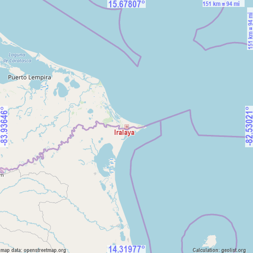
Iralaya GPS coordinates[2]
15° 0' 0" North, 83° 13' 59.988" West
| Map corner | latitude | longitude |
|---|---|---|
| Upper-left | 15.67807°, | -83.93646° |
| Center: | 15°, | -83.23333° |
| Lower-right: | 14.31977°, | -82.53021° |
| Map W x H: | 151×151 km | = 93.8×93.8mi |
| max Lat: | 16.45° ⇑42.8% North |
| Iralaya: | 15° |
| min Lat: | ⇓57.2% South 13.11667° |
| min Long | Iralaya | max Long |
| -89.23333° | -83.23333° | -83.23333° |
| W 100%⇐ | ⇒0% E |
Elevation
Elevation of Iralaya is 5 m = 16 ft, and this is 556.2 m = 1825 ft below average elevation for this country.
| Max E: |
1811 m = 5942 ft | 98.4% |
| Avg. | 561.2 m = 1841 ft | |
| Iralaya | 5 m = 16 ft | |
Min E: |
1 m = 3 ft | 1.6% |
See also: Honduras elevation on elevation.city.
Geographical zone
Iralaya is located in North Torrid zone (between Equator and Tropic of Cancer). Distance of this Northern Tropic circle is 938.1 km =582.9 mi to North.| Distance of | km | miles | from Iralaya |
|---|---|---|---|
| North Pole | 8339.2 | 5181.7 | to North |
| Arctic Circle | 5733.3 | 3562.5 | to North |
| Tropic Cancer | 938.1 | 582.9 | to North |
| Equator | 1667.8 | 1036.3 | to South |


Nearby cities:
15 places around Iralaya: (largest is in red/bold)
• Auas
129.7 km =80.6 mi,  294°
294°
• Auka
64.7 km =40.2 mi,  264°
264°
• Barra Patuca
143.5 km =89.2 mi,  308°
308°
• Brus Laguna
157.8 km =98.1 mi,  301°
301°
• Cusuna
234.3 km =145.6 mi, 293°
• Dulce Nombre de Culmí
247.2 km =153.6 mi,  272°
272°
• Francia
269 km =167.1 mi, 290°
• Palkaka
76.5 km =47.5 mi, 297°
• Paptalaya
128.8 km =80 mi, 295°
• Puerto Lempira
65 km =40.4 mi, 297°
• Punta Piedra
241.4 km =150 mi, 294°
• San José de Río Tinto
265.1 km =164.7 mi, 268°
• Tikiraya
43 km =26.7 mi, 272°
• Waksma
134.1 km =83.3 mi, 291°
• Wawina
136.8 km =85 mi, 289°
Sources, notices
• [Note1] Compared only with cities in Honduras existing in our database
• [Src1] Map data: © OpenStreetMap contributors (CC-BY-SA)
• [Src2] Other city data from geonames.org with taken over terms of usage.
• [Src3] Geographical zone / Annual Mean Temperature by Robert A. Rohde @ Wikipedia
