Reitoca geodata
Reitoca (Francisco Morazán) is a populated place; located in Honduras in America/Tegucigalpa (GMT-6) time zone. With population of 1,094 people, there are 364 cities with bigger population in this country. Compared to other cities in Honduras, 90.6% of cities are located further ↑North; 55.8% of cities are located further ←West and 65.2% of cities have higher elevation than Reitoca. Note1


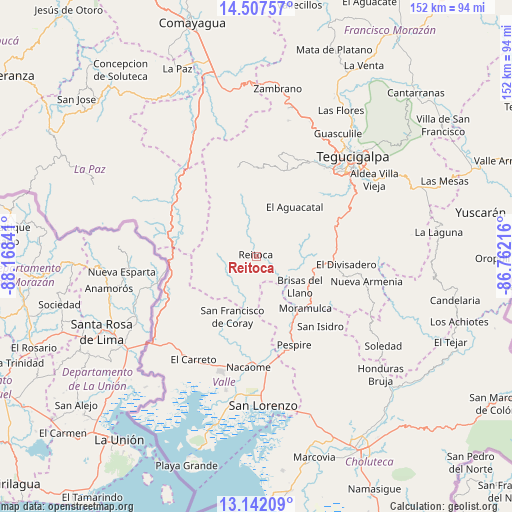
Reitoca GPS coordinates[2]
13° 49' 32.988" North, 87° 27' 55.008" West
| Map corner | latitude | longitude |
|---|---|---|
| Upper-left | 14.50757°, | -88.16841° |
| Center: | 13.82583°, | -87.46528° |
| Lower-right: | 13.14209°, | -86.76216° |
| Map W x H: | 151.8×151.8 km | = 94.3×94.3mi |
| max Lat: | 16.45° ⇑90.6% North |
| Reitoca: | 13.82583° |
| min Lat: | ⇓9.4% South 13.11667° |
| min Long | Reitoca | max Long |
| -89.23333° | -87.46528° | -83.23333° |
| W 55.8%⇐ | ⇒44.2% E |
Elevation
Elevation of Reitoca is 304 m = 997 ft, and this is 257.2 m = 844 ft below average elevation for this country.
| Max E: |
1811 m = 5942 ft | 65.2% |
| Avg. | 561.2 m = 1841 ft | |
| Reitoca | 304 m = 997 ft | |
Min E: |
1 m = 3 ft | 34.8% |
See also: Honduras elevation on elevation.city.
Geographical zone
Reitoca is located in North Torrid zone (between Equator and Tropic of Cancer). Distance of this Northern Tropic circle is 1068.6 km =664 mi to North.| Distance of | km | miles | from Reitoca |
|---|---|---|---|
| North Pole | 8469.8 | 5262.9 | to North |
| Arctic Circle | 5863.9 | 3643.7 | to North |
| Tropic Cancer | 1068.6 | 664 | to North |
| Equator | 1537.3 | 955.2 | to South |


Nearby cities:
15 places around Reitoca: (largest is in red/bold)
• Alubarén
3.3 km =2.1 mi,  186°
186°
• Aramecina
28 km =17.4 mi,  250°
250°
• Cerro Grande
23.3 km =14.5 mi,  92°
92°
• El Guapinol
6.6 km =4.1 mi,  181°
181°
• El Porvenir
14.7 km =9.1 mi,  118°
118°
• Goascorán
31.5 km =19.6 mi,  211°
211°
• Langue
30.5 km =19 mi,  221°
221°
• Lepaterique
26.8 km =16.7 mi,  359°
359°
• Nacaome
32.3 km =20.1 mi, 184°
• Ojojona
21.9 km =13.6 mi,  56°
56°
• Pespire
28.3 km =17.6 mi,  156°
156°
• Sabanagrande
22.3 km =13.9 mi,  95°
95°
• San Antonio del Norte
26.5 km =16.5 mi,  284°
284°
• San Francisco de Coray
19.7 km =12.2 mi,  201°
201°
• Santa Ana
24 km =14.9 mi, 60°
Sources, notices
• [Note1] Compared only with cities in Honduras existing in our database
• [Src1] Map data: © OpenStreetMap contributors (CC-BY-SA)
• [Src2] Other city data from geonames.org with taken over terms of usage.
• [Src3] Geographical zone / Annual Mean Temperature by Robert A. Rohde @ Wikipedia
