San Antonio del Norte geodata
San Antonio del Norte (La Paz) is a populated place; located in Honduras in America/Tegucigalpa (GMT-6) time zone. With population of 1,002 people, there are 417 cities with bigger population in this country. Compared to other cities in Honduras, 89.4% of cities are located further ↑North; 53.4% of cities are located further →East and 65.8% of cities have higher elevation than San Antonio del Norte. Note1


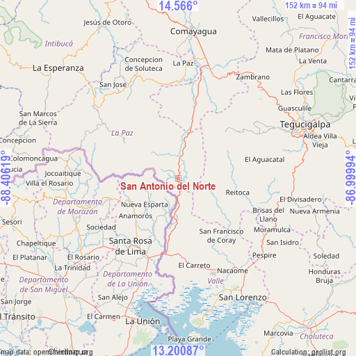
San Antonio del Norte GPS coordinates[2]
13° 53' 3.984" North, 87° 42' 11.016" West
| Map corner | latitude | longitude |
|---|---|---|
| Upper-left | 14.566°, | -88.40619° |
| Center: | 13.88444°, | -87.70306° |
| Lower-right: | 13.20087°, | -86.99994° |
| Map W x H: | 151.8×151.8 km | = 94.3×94.3mi |
| max Lat: | 16.45° ⇑89.4% North |
| San Antonio del Norte: | 13.88444° |
| min Lat: | ⇓10.6% South 13.11667° |
| min Long | San Antonio del | max Long |
| -89.23333° | -87.70306° | -83.23333° |
| W 46.6%⇐ | ⇒53.4% E |
Elevation
Elevation of San Antonio del Norte is 301 m = 988 ft, and this is 260.2 m = 854 ft below average elevation for this country.
| Max E: |
1811 m = 5942 ft | 65.8% |
| Avg. | 561.2 m = 1841 ft | |
| San Antonio del Norte | 301 m = 988 ft | |
Min E: |
1 m = 3 ft | 34.2% |
See also: Honduras elevation on elevation.city.
Geographical zone
San Antonio del Norte is located in North Torrid zone (between Equator and Tropic of Cancer). Distance of this Northern Tropic circle is 1062.1 km =660 mi to North.| Distance of | km | miles | from San Antonio del Norte |
|---|---|---|---|
| North Pole | 8463.3 | 5258.8 | to North |
| Arctic Circle | 5857.4 | 3639.6 | to North |
| Tropic Cancer | 1062.1 | 660 | to North |
| Equator | 1543.8 | 959.3 | to South |


Nearby cities:
15 places around San Antonio del Norte: (largest is in red/bold)
• Alubarén
27.1 km =16.8 mi,  111°
111°
• Aramecina
15.8 km =9.8 mi,  182°
182°
• El Guapinol
28.7 km =17.8 mi,  117°
117°
• El Porvenir
40.9 km =25.4 mi, 109°
• Goascorán
34.8 km =21.6 mi,  164°
164°
• La Alianza
41.5 km =25.8 mi, 183°
• La Florida
36.4 km =22.6 mi,  303°
303°
• Lamaní
36.3 km =22.6 mi,  14°
14°
• Langue
29.8 km =18.5 mi,  169°
169°
• Lepaterique
32.6 km =20.3 mi,  51°
51°
• Los Planes
38.5 km =23.9 mi, 298°
• Reitoca
26.5 km =16.5 mi,  104°
104°
• San Francisco de Coray
30.9 km =19.2 mi,  143°
143°
• San Pedro de Tutule
43.6 km =27.1 mi,  338°
338°
• San Sebastián
41.3 km =25.7 mi, 10°
Sources, notices
• [Note1] Compared only with cities in Honduras existing in our database
• [Src1] Map data: © OpenStreetMap contributors (CC-BY-SA)
• [Src2] Other city data from geonames.org with taken over terms of usage.
• [Src3] Geographical zone / Annual Mean Temperature by Robert A. Rohde @ Wikipedia
