Ayapa geodata
Ayapa (Yoro) is a populated place; located in Honduras in America/Tegucigalpa (GMT-6) time zone. With population of 1,559 people, there are 230 cities with bigger population in this country. Compared to other cities in Honduras, 65% of cities are located further ↓South; 67.2% of cities are located further ←West and 55.2% of cities have lower elevation than Ayapa. Note1


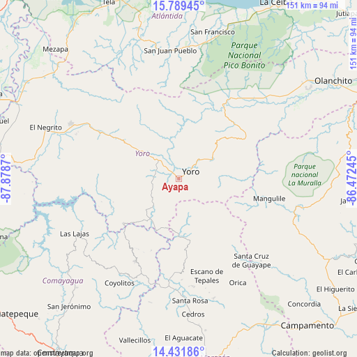
Ayapa GPS coordinates[2]
15° 6' 42.264" North, 87° 10' 32.052" West
| Map corner | latitude | longitude |
|---|---|---|
| Upper-left | 15.78945°, | -87.8787° |
| Center: | 15.11174°, | -87.17557° |
| Lower-right: | 14.43186°, | -86.47245° |
| Map W x H: | 150.9×151 km | = 93.8×93.8mi |
| max Lat: | 16.45° ⇑35% North |
| Ayapa: | 15.11174° |
| min Lat: | ⇓65% South 13.11667° |
| min Long | Ayapa | max Long |
| -89.23333° | -87.17557° | -83.23333° |
| W 67.2%⇐ | ⇒32.8% E |
Elevation
Elevation of Ayapa is 642 m = 2106 ft, and this is 80.8 m = 265 ft above average elevation for this country.
| Max E: |
1811 m = 5942 ft | 44.8% |
| Ayapa | 642 m 2106 ft | |
| Avg. | 561.2 m = 1841 ft | |
Min E: |
1 m = 3 ft | 55.2% |
See also: Honduras elevation on elevation.city.
Geographical zone
Ayapa is located in North Torrid zone (between Equator and Tropic of Cancer). Distance of this Northern Tropic circle is 925.7 km =575.2 mi to North.| Distance of | km | miles | from Ayapa |
|---|---|---|---|
| North Pole | 8326.8 | 5174 | to North |
| Arctic Circle | 5720.9 | 3554.8 | to North |
| Tropic Cancer | 925.7 | 575.2 | to North |
| Equator | 1680.3 | 1044.1 | to South |


Nearby cities:
15 places around Ayapa: (largest is in red/bold)
• Jocón
29.4 km =18.3 mi,  49°
49°
• La Rosa
29 km =18 mi,  23°
23°
• La Trinidad
2.9 km =1.8 mi,  243°
243°
• Las Vegas
31.3 km =19.4 mi,  250°
250°
• Lomitas
4.6 km =2.9 mi, 253°
• Marale
25.5 km =15.8 mi,  173°
173°
• Paujiles
18.8 km =11.7 mi,  266°
266°
• Punta Ocote
15.2 km =9.4 mi,  310°
310°
• San Antonio
24.8 km =15.4 mi,  6°
6°
• San José
22.8 km =14.2 mi,  2°
2°
• Santa Rita
13.1 km =8.1 mi,  297°
297°
• Subirana
31 km =19.3 mi,  288°
288°
• Sulaco
23.8 km =14.8 mi,  204°
204°
• Yorito
12.6 km =7.8 mi, 246°
• Yoro
5.9 km =3.7 mi,  60°
60°
Sources, notices
• [Note1] Compared only with cities in Honduras existing in our database
• [Src1] Map data: © OpenStreetMap contributors (CC-BY-SA)
• [Src2] Other city data from geonames.org with taken over terms of usage.
• [Src3] Geographical zone / Annual Mean Temperature by Robert A. Rohde @ Wikipedia
