Jocón geodata
Jocón (Yoro) is a populated place; located in Honduras in America/Tegucigalpa (GMT-6) time zone. With population of 1,731 people, there are 212 cities with bigger population in this country. Compared to other cities in Honduras, 72% of cities are located further ↓South; 75.4% of cities are located further ←West and 82.2% of cities have lower elevation than Jocón. Note1


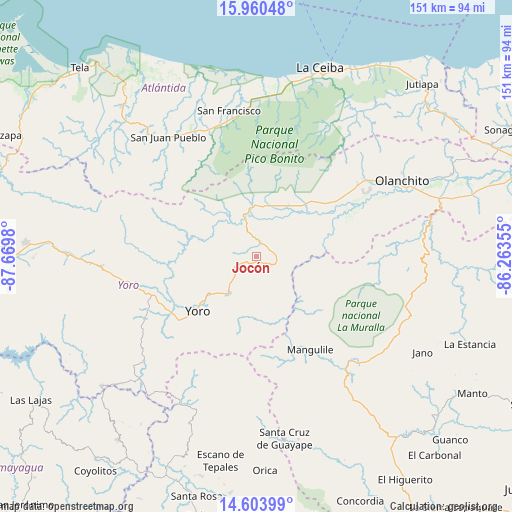
Jocón GPS coordinates[2]
15° 16' 59.988" North, 86° 58' 0.012" West
| Map corner | latitude | longitude |
|---|---|---|
| Upper-left | 15.96048°, | -87.6698° |
| Center: | 15.28333°, | -86.96667° |
| Lower-right: | 14.60399°, | -86.26355° |
| Map W x H: | 150.8×150.8 km | = 93.7×93.7mi |
| max Lat: | 16.45° ⇑28% North |
| Jocón: | 15.28333° |
| min Lat: | ⇓72% South 13.11667° |
| min Long | Jocón | max Long |
| -89.23333° | -86.96667° | -83.23333° |
| W 75.4%⇐ | ⇒24.6% E |
Elevation
Elevation of Jocón is 973 m = 3192 ft, and this is 411.8 m = 1351 ft above average elevation for this country.
| Max E: |
1811 m = 5942 ft | 17.8% |
| Jocón | 973 m 3192 ft | |
| Avg. | 561.2 m = 1841 ft | |
Min E: |
1 m = 3 ft | 82.2% |
See also: Honduras elevation on elevation.city.
Geographical zone
Jocón is located in North Torrid zone (between Equator and Tropic of Cancer). Distance of this Northern Tropic circle is 906.6 km =563.3 mi to North.| Distance of | km | miles | from Jocón |
|---|---|---|---|
| North Pole | 8307.7 | 5162.2 | to North |
| Arctic Circle | 5701.8 | 3542.9 | to North |
| Tropic Cancer | 906.6 | 563.3 | to North |
| Equator | 1699.3 | 1055.9 | to South |


Nearby cities:
15 places around Jocón: (largest is in red/bold)
• Arenal
16.1 km =10 mi,  62°
62°
• Ayapa
29.4 km =18.3 mi,  229°
229°
• Coyoles
36.6 km =22.7 mi, 56°
• Coyoles Central
34.7 km =21.6 mi,  68°
68°
• La Rosa
13 km =8.1 mi,  304°
304°
• La Trinidad
32.3 km =20.1 mi, 230°
• Lomitas
33.7 km =20.9 mi, 232°
• Mangulile
30 km =18.6 mi,  143°
143°
• Nombre de Jesús
31.3 km =19.4 mi,  76°
76°
• Punta Ocote
35.2 km =21.9 mi,  254°
254°
• San Antonio
20.4 km =12.7 mi,  285°
285°
• San José
21.8 km =13.5 mi,  279°
279°
• Santa Rita
36.4 km =22.6 mi, 249°
• Trojas
29.5 km =18.3 mi, 75°
• Yoro
23.7 km =14.7 mi, 226°
Sources, notices
• [Note1] Compared only with cities in Honduras existing in our database
• [Src1] Map data: © OpenStreetMap contributors (CC-BY-SA)
• [Src2] Other city data from geonames.org with taken over terms of usage.
• [Src3] Geographical zone / Annual Mean Temperature by Robert A. Rohde @ Wikipedia
