Marale geodata
Marale (Francisco Morazán) is a populated place; located in Honduras in America/Tegucigalpa (GMT-6) time zone. With population of 1,523 people, there are 235 cities with bigger population in this country. Compared to other cities in Honduras, 50.2% of cities are located further ↑North; 67.8% of cities are located further ←West and 68.6% of cities have lower elevation than Marale. Note1


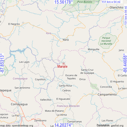
Marale GPS coordinates[2]
14° 52' 59.988" North, 87° 9' 0" West
| Map corner | latitude | longitude |
|---|---|---|
| Upper-left | 15.56178°, | -87.85313° |
| Center: | 14.88333°, | -87.15° |
| Lower-right: | 14.20274°, | -86.44688° |
| Map W x H: | 151.1×151.1 km | = 93.9×93.9mi |
| max Lat: | 16.45° ⇑50.2% North |
| Marale: | 14.88333° |
| min Lat: | ⇓49.8% South 13.11667° |
| min Long | Marale | max Long |
| -89.23333° | -87.15° | -83.23333° |
| W 67.8%⇐ | ⇒32.2% E |
Elevation
Elevation of Marale is 758 m = 2487 ft, and this is 196.8 m = 646 ft above average elevation for this country.
| Max E: |
1811 m = 5942 ft | 31.4% |
| Marale | 758 m 2487 ft | |
| Avg. | 561.2 m = 1841 ft | |
Min E: |
1 m = 3 ft | 68.6% |
See also: Honduras elevation on elevation.city.
Geographical zone
Marale is located in North Torrid zone (between Equator and Tropic of Cancer). Distance of this Northern Tropic circle is 951 km =590.9 mi to North.| Distance of | km | miles | from Marale |
|---|---|---|---|
| North Pole | 8352.2 | 5189.8 | to North |
| Arctic Circle | 5746.3 | 3570.6 | to North |
| Tropic Cancer | 951 | 590.9 | to North |
| Equator | 1654.9 | 1028.3 | to South |


Nearby cities:
15 places around Marale: (largest is in red/bold)
• Ayapa
25.5 km =15.8 mi,  353°
353°
• El Escanito
24.7 km =15.3 mi,  167°
167°
• El Escaño de Tepale
17.3 km =10.7 mi,  148°
148°
• El Pedernal
20.7 km =12.9 mi, 170°
• Esquías
28.6 km =17.8 mi,  234°
234°
• La Trinidad
24.7 km =15.3 mi, 347°
• Lomitas
25.1 km =15.6 mi,  343°
343°
• Minas de Oro
23.4 km =14.5 mi,  246°
246°
• San Ignacio
28.8 km =17.9 mi, 154°
• San José del Potrero
15.4 km =9.6 mi, 248°
• San Nicolás
28.4 km =17.6 mi, 229°
• Sulaco
13.1 km =8.1 mi,  286°
286°
• Urrutia
19.4 km =12.1 mi,  139°
139°
• Yorito
24.9 km =15.5 mi,  324°
324°
• Yoro
28.4 km =17.6 mi,  4°
4°
Sources, notices
• [Note1] Compared only with cities in Honduras existing in our database
• [Src1] Map data: © OpenStreetMap contributors (CC-BY-SA)
• [Src2] Other city data from geonames.org with taken over terms of usage.
• [Src3] Geographical zone / Annual Mean Temperature by Robert A. Rohde @ Wikipedia
