La Rosa geodata
La Rosa (Yoro) is a populated place; located in Honduras in America/Tegucigalpa (GMT-6) time zone. With population of 1,552 people, there are 231 cities with bigger population in this country. Compared to other cities in Honduras, 76.2% of cities are located further ↓South; 72% of cities are located further ←West and 76.4% of cities have lower elevation than La Rosa. Note1


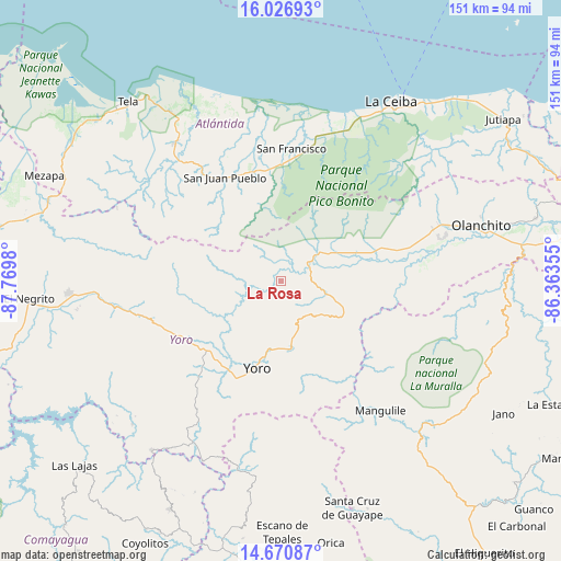
La Rosa GPS coordinates[2]
15° 21' 0" North, 87° 4' 0.012" West
| Map corner | latitude | longitude |
|---|---|---|
| Upper-left | 16.02693°, | -87.7698° |
| Center: | 15.35°, | -87.06667° |
| Lower-right: | 14.67087°, | -86.36355° |
| Map W x H: | 150.8×150.8 km | = 93.7×93.7mi |
| max Lat: | 16.45° ⇑23.8% North |
| La Rosa: | 15.35° |
| min Lat: | ⇓76.2% South 13.11667° |
| min Long | La Rosa | max Long |
| -89.23333° | -87.06667° | -83.23333° |
| W 72%⇐ | ⇒28% E |
Elevation
Elevation of La Rosa is 866 m = 2841 ft, and this is 304.8 m = 1000 ft above average elevation for this country.
| Max E: |
1811 m = 5942 ft | 23.6% |
| La Rosa | 866 m 2841 ft | |
| Avg. | 561.2 m = 1841 ft | |
Min E: |
1 m = 3 ft | 76.4% |
See also: Honduras elevation on elevation.city.
Geographical zone
La Rosa is located in North Torrid zone (between Equator and Tropic of Cancer). Distance of this Northern Tropic circle is 899.2 km =558.7 mi to North.| Distance of | km | miles | from La Rosa |
|---|---|---|---|
| North Pole | 8300.3 | 5157.6 | to North |
| Arctic Circle | 5694.4 | 3538.3 | to North |
| Tropic Cancer | 899.2 | 558.7 | to North |
| Equator | 1706.8 | 1060.6 | to South |


Nearby cities:
15 places around La Rosa: (largest is in red/bold)
• Arenal
25 km =15.5 mi,  90°
90°
• Ayapa
29 km =18 mi,  203°
203°
• Jocón
13 km =8.1 mi,  124°
124°
• La Masica
30.1 km =18.7 mi,  349°
349°
• La Trinidad
31.3 km =19.4 mi,  207°
207°
• Lomitas
32.1 km =19.9 mi, 210°
• Punta Ocote
28.6 km =17.8 mi,  234°
234°
• San Antonio
9.1 km =5.7 mi,  258°
258°
• San Antonio
29.2 km =18.1 mi,  342°
342°
• San Francisco
33.4 km =20.8 mi,  3°
3°
• San José
11.3 km =7 mi,  250°
250°
• San Juan Pueblo
31.5 km =19.6 mi,  325°
325°
• Santa Ana
33.4 km =20.8 mi, 0°
• Santa Rita
30.9 km =19.2 mi, 228°
• Yoro
24.5 km =15.2 mi, 195°
Sources, notices
• [Note1] Compared only with cities in Honduras existing in our database
• [Src1] Map data: © OpenStreetMap contributors (CC-BY-SA)
• [Src2] Other city data from geonames.org with taken over terms of usage.
• [Src3] Geographical zone / Annual Mean Temperature by Robert A. Rohde @ Wikipedia
