Vrhovine geodata
Vrhovine (Ličko-Senjska) is a seat of a second-order administrative division; located in Croatia in Europe/Zagreb (GMT+2) time zone. In our database, there are 904 cities with bigger population. Compared to other cities in Croatia, 77% of cities are located further ↑North; 83.8% of cities are located further →East and 99.4% of cities have lower elevation than Vrhovine. Note1


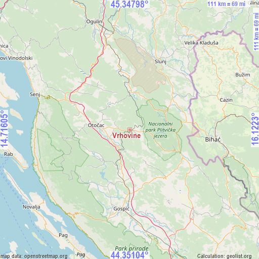
Vrhovine GPS coordinates[2]
44° 51' 6.012" North, 15° 25' 9.012" East
| Map corner | latitude | longitude |
|---|---|---|
| Upper-left | 45.34798°, | 14.71605° |
| Center: | 44.85167°, | 15.41917° |
| Lower-right: | 44.35104°, | 16.1223° |
| Map W x H: | 110.8×110.8 km | = 68.8×68.8mi |
| max Lat: | 46.52694° ⇑77% North |
| Vrhovine: | 44.85167° |
| min Lat: | ⇓23% South 42.54972° |
| min Long | Vrhovine | max Long |
| 13.52389° | 15.41917° | 19.37694° |
| W 16.2%⇐ | ⇒83.8% E |
Elevation
Elevation of Vrhovine is 726 m = 2382 ft, and this is 572.7 m = 1879 ft above average elevation for this country.
| Max E: |
827 m = 2713 ft | 0.59999999999999% |
| Vrhovine | 726 m 2382 ft | |
| Avg. | 153.3 m = 503 ft | |
Min E: |
-1 m = -3 ft | 99.4% |
See also: Croatia elevation on elevation.city.
Geographical zone
Vrhovine is located in North temperate zone (between Tropic of Cancer and the Arctic Circle). Distance of this Northern Tropic circle is 2381.1 km =1479.5 mi to South.| Distance of | km | miles | from Vrhovine |
|---|---|---|---|
| North Pole | 5020 | 3119.3 | to North |
| Arctic Circle | 2414.1 | 1500.1 | to North |
| Tropic Cancer | 2381.1 | 1479.5 | to South |
| Equator | 4987 | 3098.8 | to South |


Nearby cities:
15 places around Vrhovine: (largest is in red/bold)
• Brinje
28 km =17.4 mi,  306°
306°
• Gornji Prozor
11.7 km =7.3 mi,  265°
265°
• Korenica
25.9 km =16.1 mi,  117°
117°
• Križpolje
27.5 km =17.1 mi, 313°
• Kuterevo
22.1 km =13.7 mi,  262°
262°
• Lički Osik
27.6 km =17.1 mi,  179°
179°
• Ličko Lešće
9.1 km =5.7 mi,  234°
234°
• Otočac
14.5 km =9 mi,  277°
277°
• Perušić
22.7 km =14.1 mi,  187°
187°
• Plaški
25.3 km =15.7 mi,  350°
350°
• Popovača
30.3 km =18.8 mi,  218°
218°
• Rakovica
24.1 km =15 mi,  49°
49°
• Saborsko
15.4 km =9.6 mi,  17°
17°
• Sinac
7.3 km =4.5 mi,  250°
250°
• Čovići
9.7 km =6 mi, 254°
Sources, notices
• [Note1] Compared only with cities in Croatia existing in our database
• [Src1] Map data: © OpenStreetMap contributors (CC-BY-SA)
• [Src2] Other city data from geonames.org with taken over terms of usage.
• [Src3] Geographical zone / Annual Mean Temperature by Robert A. Rohde @ Wikipedia
