Brinje geodata
Brinje (Ličko-Senjska) is a seat of a second-order administrative division; located in Croatia in Europe/Zagreb (GMT+2) time zone. With population of 1,715 people, there are 253 cities with bigger population in this country. Compared to other cities in Croatia, 75.2% of cities are located further ↑North; 88.3% of cities are located further →East and 97.3% of cities have lower elevation than Brinje. Note1


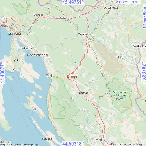
Brinje GPS coordinates[2]
45° 0' 9" North, 15° 8' 2.004" East
| Map corner | latitude | longitude |
|---|---|---|
| Upper-left | 45.49751°, | 14.43077° |
| Center: | 45.0025°, | 15.13389° |
| Lower-right: | 44.50318°, | 15.83702° |
| Map W x H: | 110.6×110.6 km | = 68.7×68.7mi |
| max Lat: | 46.52694° ⇑75.2% North |
| Brinje: | 45.0025° |
| min Lat: | ⇓24.8% South 42.54972° |
| min Long | Brinje | max Long |
| 13.52389° | 15.13389° | 19.37694° |
| W 11.7%⇐ | ⇒88.3% E |
Elevation
Elevation of Brinje is 477 m = 1565 ft, and this is 323.7 m = 1062 ft above average elevation for this country.
| Max E: |
827 m = 2713 ft | 2.7% |
| Brinje | 477 m 1565 ft | |
| Avg. | 153.3 m = 503 ft | |
Min E: |
-1 m = -3 ft | 97.3% |
See also: Croatia elevation on elevation.city.
Geographical zone
Brinje is located in North temperate zone (between Tropic of Cancer and the Arctic Circle). Distance of this North polar circle is 2397.4 km =1489.7 mi to North.| Distance of | km | miles | from Brinje |
|---|---|---|---|
| North Pole | 5003.3 | 3108.9 | to North |
| Arctic Circle | 2397.4 | 1489.7 | to North |
| Tropic Cancer | 2397.9 | 1490 | to South |
| Equator | 5003.8 | 3109.2 | to South |


Nearby cities:
15 places around Brinje: (largest is in red/bold)
• Baška
30.1 km =18.7 mi,  263°
263°
• Gornji Prozor
20.8 km =12.9 mi,  148°
148°
• Josipdol
23.6 km =14.7 mi,  30°
30°
• Križpolje
3.2 km =2 mi,  50°
50°
• Kuterevo
19.7 km =12.2 mi,  178°
178°
• Ličko Lešće
26.6 km =16.5 mi, 145°
• Ogulin
30.2 km =18.8 mi,  14°
14°
• Otočac
16.9 km =10.5 mi, 151°
• Oštarije
27 km =16.8 mi,  23°
23°
• Plaški
20.1 km =12.5 mi,  65°
65°
• Saborsko
27.1 km =16.8 mi,  94°
94°
• Senj
18 km =11.2 mi,  265°
265°
• Sinac
24.8 km =15.4 mi,  140°
140°
• Vrhovine
28 km =17.4 mi,  126°
126°
• Čovići
23.5 km =14.6 mi, 145°
Sources, notices
• [Note1] Compared only with cities in Croatia existing in our database
• [Src1] Map data: © OpenStreetMap contributors (CC-BY-SA)
• [Src2] Other city data from geonames.org with taken over terms of usage.
• [Src3] Geographical zone / Annual Mean Temperature by Robert A. Rohde @ Wikipedia
