Ilača geodata
Ilača (Vukovar-Sirmium) is a populated place; located in Croatia in Europe/Zagreb (GMT+2) time zone. With population of 859 people, there are 551 cities with bigger population in this country. Compared to other cities in Croatia, 68.8% of cities are located further ↑North; 99.5% of cities are located further ←West and 73.8% of cities have higher elevation than Ilača. Note1


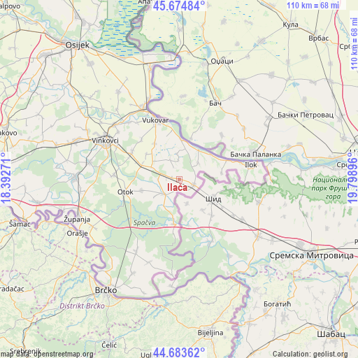
Ilača GPS coordinates[2]
45° 10' 53.004" North, 19° 5' 44.988" East
| Map corner | latitude | longitude |
|---|---|---|
| Upper-left | 45.67484°, | 18.39271° |
| Center: | 45.18139°, | 19.09583° |
| Lower-right: | 44.68362°, | 19.79896° |
| Map W x H: | 110.2×110.2 km | = 68.5×68.5mi |
| max Lat: | 46.52694° ⇑68.8% North |
| Ilača: | 45.18139° |
| min Lat: | ⇓31.2% South 42.54972° |
| min Long | Ilača | max Long |
| 13.52389° | 19.09583° | 19.37694° |
| W 99.5%⇐ | ⇒0.5% E |
Elevation
Elevation of Ilača is 90 m = 295 ft, and this is 63.3 m = 208 ft below average elevation for this country.
| Max E: |
827 m = 2713 ft | 73.8% |
| Avg. | 153.3 m = 503 ft | |
| Ilača | 90 m = 295 ft | |
Min E: |
-1 m = -3 ft | 26.2% |
See also: Croatia elevation on elevation.city.
Geographical zone
Ilača is located in North temperate zone (between Tropic of Cancer and the Arctic Circle). Distance of this North polar circle is 2377.5 km =1477.3 mi to North.| Distance of | km | miles | from Ilača |
|---|---|---|---|
| North Pole | 4983.4 | 3096.5 | to North |
| Arctic Circle | 2377.5 | 1477.3 | to North |
| Tropic Cancer | 2417.8 | 1502.4 | to South |
| Equator | 5023.7 | 3121.6 | to South |


Nearby cities:
15 places around Ilača: (largest is in red/bold)
• Bapska
13 km =8.1 mi,  82°
82°
• Komletinci
12 km =7.5 mi,  252°
252°
• Lovas
7.7 km =4.8 mi,  49°
49°
• Negoslavci
13.4 km =8.3 mi,  324°
324°
• Nijemci
6.6 km =4.1 mi,  225°
225°
• Novi Jankovci
16.9 km =10.5 mi,  292°
292°
• Orolik
9.5 km =5.9 mi, 293°
• Petrovcy
16.8 km =10.4 mi, 315°
• Slakovci
12.4 km =7.7 mi, 292°
• Sotin
13 km =8.1 mi,  359°
359°
• Srijemske Laze
14 km =8.7 mi, 293°
• Stari Jankovci
16.8 km =10.4 mi,  302°
302°
• Tompojevci
5.8 km =3.6 mi, 356°
• Tovarnik
4.8 km =3 mi,  112°
112°
• Šarengrad
15.5 km =9.6 mi,  68°
68°
Sources, notices
• [Note1] Compared only with cities in Croatia existing in our database
• [Src1] Map data: © OpenStreetMap contributors (CC-BY-SA)
• [Src2] Other city data from geonames.org with taken over terms of usage.
• [Src3] Geographical zone / Annual Mean Temperature by Robert A. Rohde @ Wikipedia
