Miragoâne geodata
Miragoâne (Nippes) is a seat of a first-order administrative division; located in Haiti in America/Port-au-Prince (GMT-4) time zone. With population of 89,202 people, there are 12 cities with bigger population in this country. Compared to other cities in Haiti, 74.5% of cities are located further ↑North; 69.8% of cities are located further →East and 51.9% of cities have lower elevation than Miragoâne. Note1


Miragoâne GPS coordinates[2]
18° 26' 45.564" North, 73° 5' 22.452" West
| Map corner | latitude | longitude |
|---|---|---|
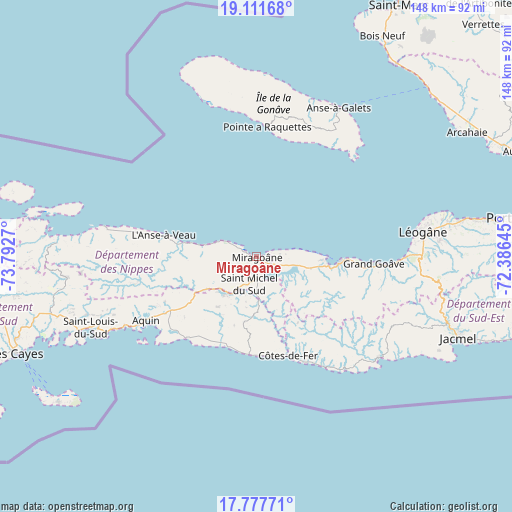
| Upper-left | 19.11168°, | -73.7927° |
| Center: | 18.44599°, | -73.08957° |
| Lower-right: | 17.77771°, | -72.38645° |
| Map W x H: | 148.3×148.3 km | = 92.1×92.1mi |
| max Lat: | 19.93984° ⇑74.5% North |
| Miragoâne: | 18.44599° |
| min Lat: | ⇓25.5% South 18.05° |
| min Long | Miragoâne | max Long |
| -74.4528° | -73.08957° | -71.72475° |
| W 30.2%⇐ | ⇒69.8% E |
Elevation
Elevation of Miragoâne is 38 m = 125 ft, and this is 107.1 m = 351 ft below average elevation for this country.
| Max E: |
1466 m = 4810 ft | 48.1% |
| Avg. | 145.1 m = 476 ft | |
| Miragoâne | 38 m = 125 ft | |
Min E: |
3 m = 10 ft | 51.9% |
See also: Miragoâne elevation on elevation.city.
Geographical zone
Miragoâne is located in North Torrid zone (between Equator and Tropic of Cancer). Distance of this Northern Tropic circle is 554.9 km =344.8 mi to North.| Distance of | km | miles | from Miragoâne |
|---|---|---|---|
| North Pole | 7956.1 | 4943.7 | to North |
| Arctic Circle | 5350.2 | 3324.5 | to North |
| Tropic Cancer | 554.9 | 344.8 | to North |
| Equator | 2051 | 1274.4 | to South |


Nearby cities:
15 places around Miragoâne: (largest is in red/bold)
• Anse à Galets
49.2 km =30.6 mi,  28°
28°
• Anse-à-Veau
27.6 km =17.1 mi,  282°
282°
• Aquin
37.1 km =23.1 mi,  240°
240°
• Baradères
58.1 km =36.1 mi,  274°
274°
• Cavaillon
61.8 km =38.4 mi,  254°
254°
• Fond des Blancs
19.1 km =11.9 mi,  192°
192°
• Grangwav
33.8 km =21 mi,  93°
93°
• Gressier
60.3 km =37.5 mi,  79°
79°
• Kotdefè
30 km =18.6 mi,  162°
162°
• Lazil
34.9 km =21.7 mi,  258°
258°
• Léogâne
48.6 km =30.2 mi, 81°
• Petit Trou de Nippes
45 km =28 mi, 281°
• Petite Rivière de Nippes
15.7 km =9.8 mi, 282°
• Saint-Louis du Sud
52.3 km =32.5 mi, 247°
• Tigwav
23.7 km =14.7 mi, 93°
Sources, notices
• [Note1] Compared only with cities in Haiti existing in our database
• [Src1] Map data: © OpenStreetMap contributors (CC-BY-SA)
• [Src2] Other city data from geonames.org with taken over terms of usage.
• [Src3] Geographical zone / Annual Mean Temperature by Robert A. Rohde @ Wikipedia
