Anse-à-Pitre geodata
Anse-à-Pitre (Sud-Est) is a populated place; located in Haiti in America/Port-au-Prince (GMT-4) time zone. With population of 1,736 people, there are 84 cities with bigger population in this country. Compared to other cities in Haiti, 100% of cities are located further ↑North; 99.1% of cities are located further ←West and 53.8% of cities have higher elevation than Anse-à-Pitre. Note1


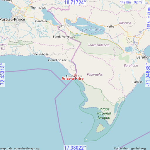
Anse-à-Pitre GPS coordinates[2]
18° 3' 0" North, 71° 45' 0" West
| Map corner | latitude | longitude |
|---|---|---|
| Upper-left | 18.71724°, | -72.45313° |
| Center: | 18.05°, | -71.75° |
| Lower-right: | 17.38022°, | -71.04688° |
| Map W x H: | 148.7×148.7 km | = 92.4×92.4mi |
| max Lat: | 19.93984° ⇑100% North |
| Anse-à-Pitre: | 18.05° |
| min Lat: | ⇓0% South 18.05° |
| min Long | Anse-à-Pitre | max Long |
| -74.4528° | -71.75° | -71.72475° |
| W 99.1%⇐ | ⇒0.90000000000001% E |
Elevation
Elevation of Anse-à-Pitre is 30 m = 98 ft, and this is 115.1 m = 378 ft below average elevation for this country.
| Max E: |
1466 m = 4810 ft | 53.8% |
| Avg. | 145.1 m = 476 ft | |
| Anse-à-Pitre | 30 m = 98 ft | |
Min E: |
3 m = 10 ft | 46.2% |
See also: Haiti elevation on elevation.city.
Geographical zone
Anse-à-Pitre is located in North Torrid zone (between Equator and Tropic of Cancer). Distance of this Northern Tropic circle is 598.9 km =372.1 mi to North.| Distance of | km | miles | from Anse-à-Pitre |
|---|---|---|---|
| North Pole | 8000.1 | 4971 | to North |
| Arctic Circle | 5394.2 | 3351.8 | to North |
| Tropic Cancer | 598.9 | 372.1 | to North |
| Equator | 2007 | 1247.1 | to South |


Nearby cities:
15 places around Anse-à-Pitre: (largest is in red/bold)
• Belle-Anse
39.4 km =24.5 mi,  301°
301°
• Carrefour
87.6 km =54.4 mi,  308°
308°
• Cayes-Jacmel
71.1 km =44.2 mi,  286°
286°
• Cornillon
72.8 km =45.2 mi,  342°
342°
• Croix-des-Bouquets
77.2 km =48 mi,  319°
319°
• Delmas 73
80.2 km =49.8 mi, 313°
• Fond Parisien
56.2 km =34.9 mi,  334°
334°
• Fonds Verrettes
40 km =24.9 mi, 343°
• Jacmel
85.5 km =53.1 mi,  283°
283°
• Kenscoff
71.7 km =44.6 mi, 308°
• Marigot
63.8 km =39.6 mi, 288°
• Port-au-Prince
82.9 km =51.5 mi, 311°
• Pétionville
76.4 km =47.5 mi, 312°
• Thiotte
23.6 km =14.7 mi, 335°
• Thomazeau
76.2 km =47.3 mi, 331°
In other languages:
- In France: Anse-à-Pitre, Anses à Pitre, Anse Pitres, Anses-a-Pîtres, Anse-à-Pitres
Sources, notices
• [Note1] Compared only with cities in Haiti existing in our database
• [Src1] Map data: © OpenStreetMap contributors (CC-BY-SA)
• [Src2] Other city data from geonames.org with taken over terms of usage.
• [Src3] Geographical zone / Annual Mean Temperature by Robert A. Rohde @ Wikipedia
