Tab geodata
Tab (Somogy) is a seat of a second-order administrative division; located in Hungary in Europe/Budapest (GMT+2) time zone. With population of 4,824 people, there are 310 cities with bigger population in this country. Compared to other cities in Hungary, 79.3% of cities are located further ↑North; 85.3% of cities are located further →East and 85% of cities have lower elevation than Tab. Note1


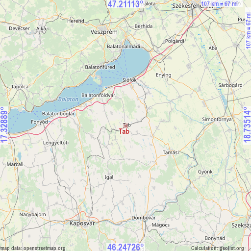
Tab GPS coordinates[2]
46° 43' 52.86" North, 18° 1' 55.236" East
| Map corner | latitude | longitude |
|---|---|---|
| Upper-left | 47.21113°, | 17.32889° |
| Center: | 46.73135°, | 18.03201° |
| Lower-right: | 46.24726°, | 18.73514° |
| Map W x H: | 107.2×107.2 km | = 66.6×66.6mi |
| max Lat: | 48.46667° ⇑79.3% North |
| Tab: | 46.73135° |
| min Lat: | ⇓20.7% South 45.79108° |
| min Long | Tab | max Long |
| 16.27358° | 18.03201° | 22.68096° |
| W 14.7%⇐ | ⇒85.3% E |
Elevation
Elevation of Tab is 173 m = 568 ft, and this is 43.3 m = 142 ft above average elevation for this country.
| Max E: |
444 m = 1457 ft | 15% |
| Tab | 173 m 568 ft | |
| Avg. | 129.7 m = 426 ft | |
Min E: |
71 m = 233 ft | 85% |
See also: Hungary elevation on elevation.city.
Geographical zone
Tab is located in North temperate zone (between Tropic of Cancer and the Arctic Circle). Distance of this North polar circle is 2205.1 km =1370.2 mi to North.| Distance of | km | miles | from Tab |
|---|---|---|---|
| North Pole | 4811 | 2989.4 | to North |
| Arctic Circle | 2205.1 | 1370.2 | to North |
| Tropic Cancer | 2590.1 | 1609.4 | to South |
| Equator | 5196 | 3228.6 | to South |


Nearby cities:
15 places around Tab: (largest is in red/bold)
• Balatonföldvár
17.7 km =11 mi,  319°
319°
• Balatonlelle
26.3 km =16.3 mi,  282°
282°
• Balatonszabadi
19.8 km =12.3 mi,  23°
23°
• Balatonszárszó
19.2 km =11.9 mi,  304°
304°
• Enying
27.3 km =17 mi,  35°
35°
• Iregszemcse
12.5 km =7.8 mi,  110°
110°
• Karád
15.2 km =9.4 mi,  252°
252°
• Lajoskomárom
26.3 km =16.3 mi,  62°
62°
• Ozora
28.1 km =17.5 mi,  85°
85°
• Siófok
19.3 km =12 mi,  5°
5°
• Szakcs
22.2 km =13.8 mi,  164°
164°
• Tamási
22.1 km =13.7 mi,  119°
119°
• Tihany
23 km =14.3 mi,  331°
331°
• Zamárdi
18.1 km =11.2 mi,  340°
340°
• Ádánd
17.4 km =10.8 mi, 35°
Sources, notices
• [Note1] Compared only with cities in Hungary existing in our database
• [Src1] Map data: © OpenStreetMap contributors (CC-BY-SA)
• [Src2] Other city data from geonames.org with taken over terms of usage.
• [Src3] Geographical zone / Annual Mean Temperature by Robert A. Rohde @ Wikipedia
