Pétfürdő geodata
Pétfürdő (Veszprém) is a populated place; located in Hungary in Europe/Budapest (GMT+2) time zone. With population of 4,877 people, there are 305 cities with bigger population in this country. Compared to other cities in Hungary, 63% of cities are located further ↑North; 84.3% of cities are located further →East and 70.7% of cities have lower elevation than Pétfürdő. Note1


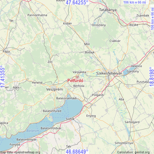
Pétfürdő GPS coordinates[2]
47° 10' 0.012" North, 18° 7' 0.012" East
| Map corner | latitude | longitude |
|---|---|---|
| Upper-left | 47.64255°, | 17.41355° |
| Center: | 47.16667°, | 18.11667° |
| Lower-right: | 46.68649°, | 18.8198° |
| Map W x H: | 106.3×106.3 km | = 66.1×66.1mi |
| max Lat: | 48.46667° ⇑63% North |
| Pétfürdő: | 47.16667° |
| min Lat: | ⇓37% South 45.79108° |
| min Long | Pétfürdő | max Long |
| 16.27358° | 18.11667° | 22.68096° |
| W 15.7%⇐ | ⇒84.3% E |
Elevation
Elevation of Pétfürdő is 138 m = 453 ft, and this is 8.3 m = 27 ft above average elevation for this country.
| Max E: |
444 m = 1457 ft | 29.3% |
| Pétfürdő | 138 m 453 ft | |
| Avg. | 129.7 m = 426 ft | |
Min E: |
71 m = 233 ft | 70.7% |
See also: Hungary elevation on elevation.city.
Geographical zone
Pétfürdő is located in North temperate zone (between Tropic of Cancer and the Arctic Circle). Distance of this North polar circle is 2156.7 km =1340.1 mi to North.| Distance of | km | miles | from Pétfürdő |
|---|---|---|---|
| North Pole | 4762.6 | 2959.3 | to North |
| Arctic Circle | 2156.7 | 1340.1 | to North |
| Tropic Cancer | 2638.5 | 1639.5 | to South |
| Equator | 5244.4 | 3258.7 | to South |


Nearby cities:
15 places around Pétfürdő: (largest is in red/bold)
• Bakonycsernye
17.8 km =11.1 mi,  349°
349°
• Balatonalmádi
16.3 km =10.1 mi,  206°
206°
• Balatonkenese
14.1 km =8.8 mi,  183°
183°
• Berhida
6.2 km =3.9 mi,  171°
171°
• Csetény
19.3 km =12 mi,  330°
330°
• Fehérvárcsurgó
18 km =11.2 mi,  38°
38°
• Hajmáskér
7.7 km =4.8 mi,  251°
251°
• Kincsesbánya
16.3 km =10.1 mi,  48°
48°
• Litér
11.2 km =7 mi,  229°
229°
• Polgárdi
18.3 km =11.4 mi,  129°
129°
• Szentkirályszabadja
16.4 km =10.2 mi,  222°
222°
• Sárszentmihály
16.9 km =10.5 mi,  95°
95°
• Veszprém
17.5 km =10.9 mi,  242°
242°
• Várpalota
4 km =2.5 mi,  25°
25°
• Ősi
5.8 km =3.6 mi,  111°
111°
Sources, notices
• [Note1] Compared only with cities in Hungary existing in our database
• [Src1] Map data: © OpenStreetMap contributors (CC-BY-SA)
• [Src2] Other city data from geonames.org with taken over terms of usage.
• [Src3] Geographical zone / Annual Mean Temperature by Robert A. Rohde @ Wikipedia
