Zirc geodata
Zirc (Veszprém) is a populated place; located in Hungary in Europe/Budapest (GMT+2) time zone. With population of 7,314 people, there are 210 cities with bigger population in this country. Compared to other cities in Hungary, 58.7% of cities are located further ↑North; 87.5% of cities are located further →East and 99.7% of cities have lower elevation than Zirc. Note1


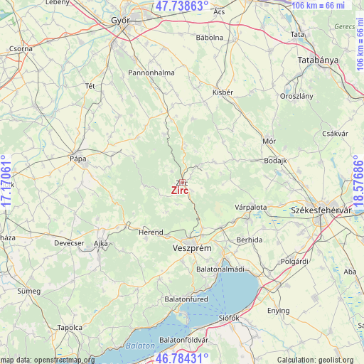
Zirc GPS coordinates[2]
47° 15' 49.032" North, 17° 52' 25.428" East
| Map corner | latitude | longitude |
|---|---|---|
| Upper-left | 47.73863°, | 17.17061° |
| Center: | 47.26362°, | 17.87373° |
| Lower-right: | 46.78431°, | 18.57686° |
| Map W x H: | 106.1×106.1 km | = 65.9×65.9mi |
| max Lat: | 48.46667° ⇑58.7% North |
| Zirc: | 47.26362° |
| min Lat: | ⇓41.3% South 45.79108° |
| min Long | Zirc | max Long |
| 16.27358° | 17.87373° | 22.68096° |
| W 12.5%⇐ | ⇒87.5% E |
Elevation
Elevation of Zirc is 395 m = 1296 ft, and this is 265.3 m = 870 ft above average elevation for this country.
| Max E: |
444 m = 1457 ft | 0.3% |
| Zirc | 395 m 1296 ft | |
| Avg. | 129.7 m = 426 ft | |
Min E: |
71 m = 233 ft | 99.7% |
See also: Hungary elevation on elevation.city.
Geographical zone
Zirc is located in North temperate zone (between Tropic of Cancer and the Arctic Circle). Distance of this North polar circle is 2146 km =1333.5 mi to North.| Distance of | km | miles | from Zirc |
|---|---|---|---|
| North Pole | 4751.8 | 2952.6 | to North |
| Arctic Circle | 2146 | 1333.5 | to North |
| Tropic Cancer | 2649.3 | 1646.2 | to South |
| Equator | 5255.2 | 3265.4 | to South |


Nearby cities:
15 places around Zirc: (largest is in red/bold)
• Bakonycsernye
16.6 km =10.3 mi,  66°
66°
• Bakonyszentlászló
14.9 km =9.3 mi,  339°
339°
• Berhida
25.7 km =16 mi,  131°
131°
• Bánd
17.2 km =10.7 mi,  203°
203°
• Csetény
10.8 km =6.7 mi,  55°
55°
• Hajmáskér
17.2 km =10.7 mi,  140°
140°
• Herend
17.2 km =10.7 mi,  212°
212°
• Litér
20.6 km =12.8 mi,  151°
151°
• Nemesvámos
23.2 km =14.4 mi,  179°
179°
• Pétfürdő
21.3 km =13.2 mi,  120°
120°
• Szentkirályszabadja
24 km =14.9 mi,  162°
162°
• Veszprém
19.2 km =11.9 mi,  171°
171°
• Várpalota
21.3 km =13.2 mi,  109°
109°
• Úrkút
26.4 km =16.4 mi,  221°
221°
• Ősi
27.1 km =16.8 mi, 118°
Sources, notices
• [Note1] Compared only with cities in Hungary existing in our database
• [Src1] Map data: © OpenStreetMap contributors (CC-BY-SA)
• [Src2] Other city data from geonames.org with taken over terms of usage.
• [Src3] Geographical zone / Annual Mean Temperature by Robert A. Rohde @ Wikipedia
