Berhida geodata
Berhida (Veszprém) is a populated place; located in Hungary in Europe/Budapest (GMT+2) time zone. With population of 5,822 people, there are 263 cities with bigger population in this country. Compared to other cities in Hungary, 65% of cities are located further ↑North; 84.1% of cities are located further →East and 64% of cities have lower elevation than Berhida. Note1


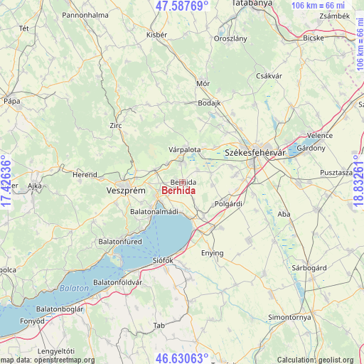
Berhida GPS coordinates[2]
47° 6' 40.716" North, 18° 7' 46.128" East
| Map corner | latitude | longitude |
|---|---|---|
| Upper-left | 47.58769°, | 17.42636° |
| Center: | 47.11131°, | 18.12948° |
| Lower-right: | 46.63063°, | 18.83261° |
| Map W x H: | 106.4×106.4 km | = 66.1×66.1mi |
| max Lat: | 48.46667° ⇑65% North |
| Berhida: | 47.11131° |
| min Lat: | ⇓35% South 45.79108° |
| min Long | Berhida | max Long |
| 16.27358° | 18.12948° | 22.68096° |
| W 15.9%⇐ | ⇒84.1% E |
Elevation
Elevation of Berhida is 130 m = 427 ft, and this is 0.30000000000001 m = 1 ft above average elevation for this country.
| Max E: |
444 m = 1457 ft | 36% |
| Berhida | 130 m 427 ft | |
| Avg. | 129.7 m = 426 ft | |
Min E: |
71 m = 233 ft | 64% |
See also: Hungary elevation on elevation.city.
Geographical zone
Berhida is located in North temperate zone (between Tropic of Cancer and the Arctic Circle). Distance of this North polar circle is 2162.9 km =1344 mi to North.| Distance of | km | miles | from Berhida |
|---|---|---|---|
| North Pole | 4768.8 | 2963.2 | to North |
| Arctic Circle | 2162.9 | 1344 | to North |
| Tropic Cancer | 2632.4 | 1635.7 | to South |
| Equator | 5238.3 | 3254.9 | to South |


Nearby cities:
15 places around Berhida: (largest is in red/bold)
• Balatonalmádi
11.8 km =7.3 mi,  224°
224°
• Balatonkenese
8.1 km =5 mi,  192°
192°
• Hajmáskér
9.1 km =5.7 mi,  294°
294°
• Kincsesbánya
20.4 km =12.7 mi,  33°
33°
• Lepsény
16 km =9.9 mi,  147°
147°
• Litér
9.5 km =5.9 mi,  263°
263°
• Nemesvámos
20.3 km =12.6 mi,  252°
252°
• Polgárdi
14.2 km =8.8 mi,  113°
113°
• Pétfürdő
6.2 km =3.9 mi,  351°
351°
• Szabadbattyán
18.1 km =11.2 mi,  87°
87°
• Szentkirályszabadja
13.4 km =8.3 mi,  243°
243°
• Sárszentmihály
16.5 km =10.3 mi,  73°
73°
• Veszprém
16.6 km =10.3 mi, 263°
• Várpalota
9.8 km =6.1 mi,  4°
4°
• Ősi
6 km =3.7 mi,  48°
48°
Sources, notices
• [Note1] Compared only with cities in Hungary existing in our database
• [Src1] Map data: © OpenStreetMap contributors (CC-BY-SA)
• [Src2] Other city data from geonames.org with taken over terms of usage.
• [Src3] Geographical zone / Annual Mean Temperature by Robert A. Rohde @ Wikipedia
