Tamási geodata
Tamási (Tolna) is a seat of a second-order administrative division; located in Hungary in Europe/Budapest (GMT+2) time zone. With population of 9,682 people, there are 172 cities with bigger population in this country. Compared to other cities in Hungary, 82.2% of cities are located further ↑North; 81.2% of cities are located further →East and 60.4% of cities have lower elevation than Tamási. Note1


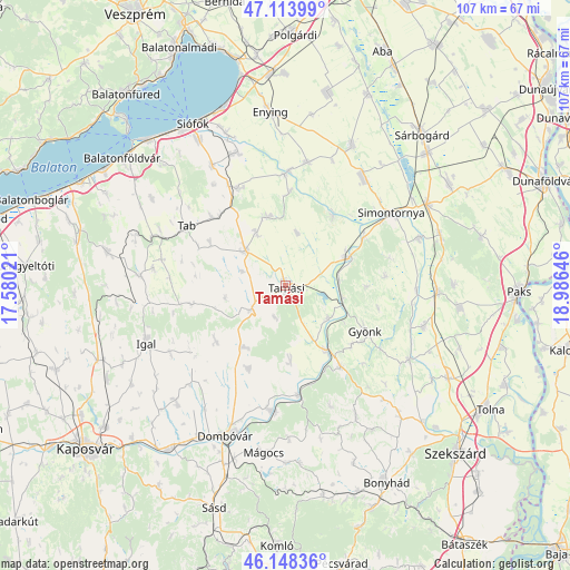
Tamási GPS coordinates[2]
46° 37' 59.988" North, 18° 16' 59.988" East
| Map corner | latitude | longitude |
|---|---|---|
| Upper-left | 47.11399°, | 17.58021° |
| Center: | 46.63333°, | 18.28333° |
| Lower-right: | 46.14836°, | 18.98646° |
| Map W x H: | 107.4×107.4 km | = 66.7×66.7mi |
| max Lat: | 48.46667° ⇑82.2% North |
| Tamási: | 46.63333° |
| min Lat: | ⇓17.8% South 45.79108° |
| min Long | Tamási | max Long |
| 16.27358° | 18.28333° | 22.68096° |
| W 18.8%⇐ | ⇒81.2% E |
Elevation
Elevation of Tamási is 126 m = 413 ft, and this is 3.7 m = 12 ft below average elevation for this country.
| Max E: |
444 m = 1457 ft | 39.6% |
| Avg. | 129.7 m = 426 ft | |
| Tamási | 126 m = 413 ft | |
Min E: |
71 m = 233 ft | 60.4% |
See also: Hungary elevation on elevation.city.
Geographical zone
Tamási is located in North temperate zone (between Tropic of Cancer and the Arctic Circle). Distance of this North polar circle is 2216 km =1377 mi to North.| Distance of | km | miles | from Tamási |
|---|---|---|---|
| North Pole | 4821.9 | 2996.2 | to North |
| Arctic Circle | 2216 | 1377 | to North |
| Tropic Cancer | 2579.2 | 1602.6 | to South |
| Equator | 5185.1 | 3221.9 | to South |


Nearby cities:
15 places around Tamási: (largest is in red/bold)
• Cece
30.4 km =18.9 mi,  59°
59°
• Dég
29 km =18 mi,  25°
25°
• Döbrököz
23.8 km =14.8 mi,  188°
188°
• Gyönk
17.1 km =10.6 mi,  120°
120°
• Hőgyész
18.3 km =11.4 mi,  145°
145°
• Iregszemcse
10 km =6.2 mi,  311°
311°
• Lajoskomárom
23.6 km =14.7 mi,  10°
10°
• Mezőszilas
24.7 km =15.3 mi,  36°
36°
• Nagydorog
28.4 km =17.6 mi,  91°
91°
• Ozora
15.9 km =9.9 mi, 34°
• Pincehely
13 km =8.1 mi,  66°
66°
• Simontornya
24.7 km =15.3 mi, 56°
• Szakcs
16.9 km =10.5 mi,  231°
231°
• Tab
22.1 km =13.7 mi,  299°
299°
• Ádánd
26.7 km =16.6 mi,  340°
340°
Sources, notices
• [Note1] Compared only with cities in Hungary existing in our database
• [Src1] Map data: © OpenStreetMap contributors (CC-BY-SA)
• [Src2] Other city data from geonames.org with taken over terms of usage.
• [Src3] Geographical zone / Annual Mean Temperature by Robert A. Rohde @ Wikipedia
