Döbrököz geodata
Döbrököz (Tolna) is a populated place; located in Hungary in Europe/Budapest (GMT+2) time zone. With population of 2,120 people, there are 734 cities with bigger population in this country. Compared to other cities in Hungary, 88.1% of cities are located further ↑North; 82.2% of cities are located further →East and 55.3% of cities have lower elevation than Döbrököz. Note1


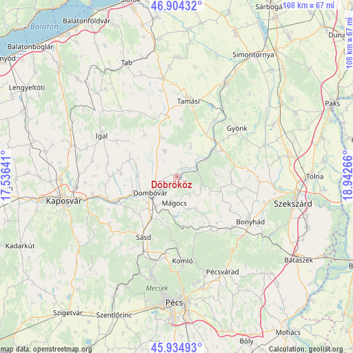
Döbrököz GPS coordinates[2]
46° 25' 18.408" North, 18° 14' 22.308" East
| Map corner | latitude | longitude |
|---|---|---|
| Upper-left | 46.90432°, | 17.53641° |
| Center: | 46.42178°, | 18.23953° |
| Lower-right: | 45.93493°, | 18.94266° |
| Map W x H: | 107.8×107.8 km | = 67×67mi |
| max Lat: | 48.46667° ⇑88.1% North |
| Döbrököz: | 46.42178° |
| min Lat: | ⇓11.9% South 45.79108° |
| min Long | Döbrököz | max Long |
| 16.27358° | 18.23953° | 22.68096° |
| W 17.8%⇐ | ⇒82.2% E |
Elevation
Elevation of Döbrököz is 121 m = 397 ft, and this is 8.7 m = 29 ft below average elevation for this country.
| Max E: |
444 m = 1457 ft | 44.7% |
| Avg. | 129.7 m = 426 ft | |
| Döbrököz | 121 m = 397 ft | |
Min E: |
71 m = 233 ft | 55.3% |
See also: Hungary elevation on elevation.city.
Geographical zone
Döbrököz is located in North temperate zone (between Tropic of Cancer and the Arctic Circle). Distance of this North polar circle is 2239.6 km =1391.6 mi to North.| Distance of | km | miles | from Döbrököz |
|---|---|---|---|
| North Pole | 4845.4 | 3010.8 | to North |
| Arctic Circle | 2239.6 | 1391.6 | to North |
| Tropic Cancer | 2555.7 | 1588 | to South |
| Equator | 5161.6 | 3207.3 | to South |


Nearby cities:
15 places around Döbrököz: (largest is in red/bold)
• Bonyhád
26.1 km =16.2 mi,  121°
121°
• Dombóvár
9.3 km =5.8 mi,  237°
237°
• Gyönk
23.5 km =14.6 mi,  50°
50°
• Gödre
25.4 km =15.8 mi,  233°
233°
• Hidas
26.9 km =16.7 mi,  133°
133°
• Hőgyész
16.1 km =10 mi,  58°
58°
• Komló
25.5 km =15.8 mi,  175°
175°
• Mágocs
8 km =5 mi, 183°
• Nagymányok
22.9 km =14.2 mi, 133°
• Szakcs
16.4 km =10.2 mi,  322°
322°
• Szászvár
19.2 km =11.9 mi,  147°
147°
• Sásd
21.1 km =13.1 mi,  208°
208°
• Tamási
23.8 km =14.8 mi,  8°
8°
• Taszár
26.1 km =16.2 mi,  258°
258°
• Zomba
25 km =15.5 mi,  92°
92°
Sources, notices
• [Note1] Compared only with cities in Hungary existing in our database
• [Src1] Map data: © OpenStreetMap contributors (CC-BY-SA)
• [Src2] Other city data from geonames.org with taken over terms of usage.
• [Src3] Geographical zone / Annual Mean Temperature by Robert A. Rohde @ Wikipedia
