Táborfalva geodata
Táborfalva (Pest) is a populated place; located in Hungary in Europe/Budapest (GMT+2) time zone. With population of 3,509 people, there are 413 cities with bigger population in this country. Compared to other cities in Hungary, 65.9% of cities are located further ↑North; 50.7% of cities are located further →East and 63% of cities have lower elevation than Táborfalva. Note1


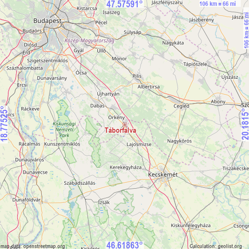
Táborfalva GPS coordinates[2]
47° 5' 57.912" North, 19° 28' 42.132" East
| Map corner | latitude | longitude |
|---|---|---|
| Upper-left | 47.57591°, | 18.77525° |
| Center: | 47.09942°, | 19.47837° |
| Lower-right: | 46.61863°, | 20.1815° |
| Map W x H: | 106.4×106.4 km | = 66.1×66.1mi |
| max Lat: | 48.46667° ⇑65.9% North |
| Táborfalva: | 47.09942° |
| min Lat: | ⇓34.1% South 45.79108° |
| min Long | Táborfalva | max Long |
| 16.27358° | 19.47837° | 22.68096° |
| W 49.3%⇐ | ⇒50.7% E |
Elevation
Elevation of Táborfalva is 129 m = 423 ft, and this is 0.69999999999999 m = 2 ft below average elevation for this country.
| Max E: |
444 m = 1457 ft | 37% |
| Avg. | 129.7 m = 426 ft | |
| Táborfalva | 129 m = 423 ft | |
Min E: |
71 m = 233 ft | 63% |
See also: Hungary elevation on elevation.city.
Geographical zone
Táborfalva is located in North temperate zone (between Tropic of Cancer and the Arctic Circle). Distance of this North polar circle is 2164.2 km =1344.8 mi to North.| Distance of | km | miles | from Táborfalva |
|---|---|---|---|
| North Pole | 4770.1 | 2964 | to North |
| Arctic Circle | 2164.2 | 1344.8 | to North |
| Tropic Cancer | 2631 | 1634.8 | to South |
| Equator | 5237 | 3254.1 | to South |


Nearby cities:
15 places around Táborfalva: (largest is in red/bold)
• Albertirsa
19.1 km =11.9 mi,  33°
33°
• Ceglédbercel
19.9 km =12.4 mi,  46°
46°
• Csemő
16.2 km =10.1 mi,  82°
82°
• Dabas
15.9 km =9.9 mi,  307°
307°
• Dánszentmiklós
13.8 km =8.6 mi,  21°
21°
• Hernád
7.8 km =4.8 mi,  333°
333°
• Inárcs
21.4 km =13.3 mi, 327°
• Kakucs
18 km =11.2 mi, 331°
• Kerekegyháza
18 km =11.2 mi,  180°
180°
• Lajosmizse
10.7 km =6.6 mi,  143°
143°
• Nagykőrös
23.9 km =14.9 mi,  107°
107°
• Nyáregyháza
18.1 km =11.2 mi,  5°
5°
• Pilis
21.7 km =13.5 mi, 14°
• Örkény
4.8 km =3 mi, 314°
• Újhartyán
15.1 km =9.4 mi, 332°
Sources, notices
• [Note1] Compared only with cities in Hungary existing in our database
• [Src1] Map data: © OpenStreetMap contributors (CC-BY-SA)
• [Src2] Other city data from geonames.org with taken over terms of usage.
• [Src3] Geographical zone / Annual Mean Temperature by Robert A. Rohde @ Wikipedia
