Dabas geodata
Dabas (Pest) is a seat of a second-order administrative division; located in Hungary in Europe/Budapest (GMT+2) time zone. With population of 16,590 people, there are 105 cities with bigger population in this country. Compared to other cities in Hungary, 62.4% of cities are located further ↑North; 54.1% of cities are located further →East and 74.5% of cities have higher elevation than Dabas. Note1


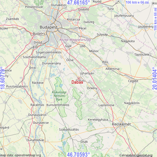
Dabas GPS coordinates[2]
47° 11' 9.384" North, 19° 18' 39.276" East
| Map corner | latitude | longitude |
|---|---|---|
| Upper-left | 47.66165°, | 18.60779° |
| Center: | 47.18594°, | 19.31091° |
| Lower-right: | 46.70593°, | 20.01404° |
| Map W x H: | 106.3×106.3 km | = 66.1×66.1mi |
| max Lat: | 48.46667° ⇑62.4% North |
| Dabas: | 47.18594° |
| min Lat: | ⇓37.6% South 45.79108° |
| min Long | Dabas | max Long |
| 16.27358° | 19.31091° | 22.68096° |
| W 45.9%⇐ | ⇒54.1% E |
Elevation
Elevation of Dabas is 99 m = 325 ft, and this is 30.7 m = 101 ft below average elevation for this country.
| Max E: |
444 m = 1457 ft | 74.5% |
| Avg. | 129.7 m = 426 ft | |
| Dabas | 99 m = 325 ft | |
Min E: |
71 m = 233 ft | 25.5% |
See also: Hungary elevation on elevation.city.
Geographical zone
Dabas is located in North temperate zone (between Tropic of Cancer and the Arctic Circle). Distance of this North polar circle is 2154.6 km =1338.8 mi to North.| Distance of | km | miles | from Dabas |
|---|---|---|---|
| North Pole | 4760.5 | 2958 | to North |
| Arctic Circle | 2154.6 | 1338.8 | to North |
| Tropic Cancer | 2640.7 | 1640.9 | to South |
| Equator | 5246.6 | 3260.1 | to South |


Nearby cities:
15 places around Dabas: (largest is in red/bold)
• Alsónémedi
18.4 km =11.4 mi,  321°
321°
• Bugyi
13.2 km =8.2 mi,  290°
290°
• Dunavarsány
21.2 km =13.2 mi,  299°
299°
• Dánszentmiklós
18.1 km =11.2 mi,  79°
79°
• Délegyháza
17.8 km =11.1 mi, 290°
• Felsőpakony
18.4 km =11.4 mi,  342°
342°
• Hernád
9.6 km =6 mi,  105°
105°
• Inárcs
8.5 km =5.3 mi,  8°
8°
• Kakucs
7.4 km =4.6 mi,  33°
33°
• Monor
21.1 km =13.1 mi, 29°
• Nyáregyháza
16.7 km =10.4 mi,  59°
59°
• Táborfalva
15.9 km =9.9 mi,  127°
127°
• Ócsa
14 km =8.7 mi,  334°
334°
• Örkény
11.2 km =7 mi,  123°
123°
• Újhartyán
6.8 km =4.2 mi, 56°
Sources, notices
• [Note1] Compared only with cities in Hungary existing in our database
• [Src1] Map data: © OpenStreetMap contributors (CC-BY-SA)
• [Src2] Other city data from geonames.org with taken over terms of usage.
• [Src3] Geographical zone / Annual Mean Temperature by Robert A. Rohde @ Wikipedia
