Iváncsa geodata
Iváncsa (Fejér) is a populated place; located in Hungary in Europe/Budapest (GMT+2) time zone. With population of 2,807 people, there are 538 cities with bigger population in this country. Compared to other cities in Hungary, 63.3% of cities are located further ↑North; 70.4% of cities are located further →East and 52.5% of cities have higher elevation than Iváncsa. Note1


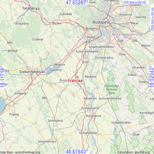
Iváncsa GPS coordinates[2]
47° 9' 24.12" North, 18° 49' 13.08" East
| Map corner | latitude | longitude |
|---|---|---|
| Upper-left | 47.63267°, | 18.11718° |
| Center: | 47.1567°, | 18.8203° |
| Lower-right: | 46.67643°, | 19.52343° |
| Map W x H: | 106.3×106.3 km | = 66.1×66.1mi |
| max Lat: | 48.46667° ⇑63.3% North |
| Iváncsa: | 47.1567° |
| min Lat: | ⇓36.7% South 45.79108° |
| min Long | Iváncsa | max Long |
| 16.27358° | 18.8203° | 22.68096° |
| W 29.6%⇐ | ⇒70.4% E |
Elevation
Elevation of Iváncsa is 114 m = 374 ft, and this is 15.7 m = 52 ft below average elevation for this country.
| Max E: |
444 m = 1457 ft | 52.5% |
| Avg. | 129.7 m = 426 ft | |
| Iváncsa | 114 m = 374 ft | |
Min E: |
71 m = 233 ft | 47.5% |
See also: Hungary elevation on elevation.city.
Geographical zone
Iváncsa is located in North temperate zone (between Tropic of Cancer and the Arctic Circle). Distance of this North polar circle is 2157.8 km =1340.8 mi to North.| Distance of | km | miles | from Iváncsa |
|---|---|---|---|
| North Pole | 4763.7 | 2960 | to North |
| Arctic Circle | 2157.8 | 1340.8 | to North |
| Tropic Cancer | 2637.4 | 1638.8 | to South |
| Equator | 5243.3 | 3258 | to South |


Nearby cities:
15 places around Iváncsa: (largest is in red/bold)
• Adony
5.3 km =3.3 mi,  140°
140°
• Baracska
14.7 km =9.1 mi,  341°
341°
• Dömsöd
16.2 km =10.1 mi,  117°
117°
• Ercsi
12 km =7.5 mi,  28°
28°
• Gárdony
15.1 km =9.4 mi,  292°
292°
• Kiskunlacháza
14.7 km =9.1 mi,  76°
76°
• Kápolnásnyék
14.3 km =8.9 mi,  310°
310°
• Perkáta
12.4 km =7.7 mi,  191°
191°
• Pusztaszabolcs
4.6 km =2.9 mi,  241°
241°
• Rácalmás
17.5 km =10.9 mi,  148°
148°
• Ráckeresztúr
13 km =8.1 mi,  4°
4°
• Ráckeve
9.4 km =5.8 mi,  87°
87°
• Szigetcsép
16.5 km =10.3 mi,  43°
43°
• Szigetújfalu
11.8 km =7.3 mi, 43°
• Velence
15.5 km =9.6 mi, 306°
Sources, notices
• [Note1] Compared only with cities in Hungary existing in our database
• [Src1] Map data: © OpenStreetMap contributors (CC-BY-SA)
• [Src2] Other city data from geonames.org with taken over terms of usage.
• [Src3] Geographical zone / Annual Mean Temperature by Robert A. Rohde @ Wikipedia
