Seregélyes geodata
Seregélyes (Fejér) is a populated place; located in Hungary in Europe/Budapest (GMT+2) time zone. With population of 4,539 people, there are 329 cities with bigger population in this country. Compared to other cities in Hungary, 65.1% of cities are located further ↑North; 75.6% of cities are located further →East and 55.3% of cities have lower elevation than Seregélyes. Note1


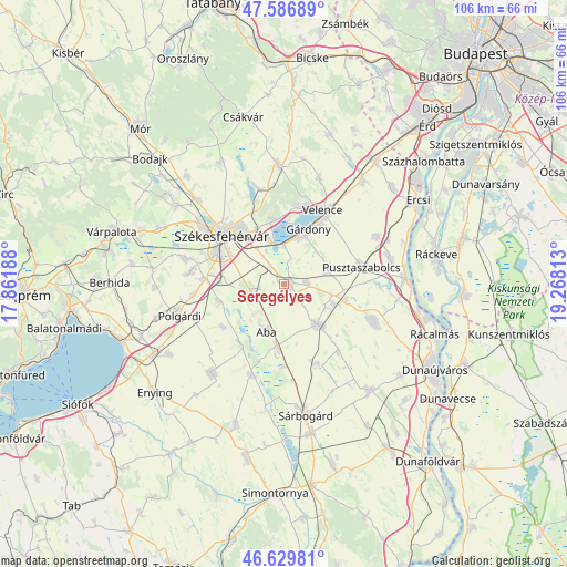
Seregélyes GPS coordinates[2]
47° 6' 37.8" North, 18° 33' 54" East
| Map corner | latitude | longitude |
|---|---|---|
| Upper-left | 47.58689°, | 17.86188° |
| Center: | 47.1105°, | 18.565° |
| Lower-right: | 46.62981°, | 19.26813° |
| Map W x H: | 106.4×106.4 km | = 66.1×66.1mi |
| max Lat: | 48.46667° ⇑65.1% North |
| Seregélyes: | 47.1105° |
| min Lat: | ⇓34.9% South 45.79108° |
| min Long | Seregélyes | max Long |
| 16.27358° | 18.565° | 22.68096° |
| W 24.4%⇐ | ⇒75.6% E |
Elevation
Elevation of Seregélyes is 121 m = 397 ft, and this is 8.7 m = 29 ft below average elevation for this country.
| Max E: |
444 m = 1457 ft | 44.7% |
| Avg. | 129.7 m = 426 ft | |
| Seregélyes | 121 m = 397 ft | |
Min E: |
71 m = 233 ft | 55.3% |
See also: Hungary elevation on elevation.city.
Geographical zone
Seregélyes is located in North temperate zone (between Tropic of Cancer and the Arctic Circle). Distance of this North polar circle is 2163 km =1344 mi to North.| Distance of | km | miles | from Seregélyes |
|---|---|---|---|
| North Pole | 4768.9 | 2963.3 | to North |
| Arctic Circle | 2163 | 1344 | to North |
| Tropic Cancer | 2632.3 | 1635.6 | to South |
| Equator | 5238.2 | 3254.9 | to South |


Nearby cities:
15 places around Seregélyes: (largest is in red/bold)
• Aba
9.6 km =6 mi,  199°
199°
• Gárdony
12.2 km =7.6 mi,  26°
26°
• Iváncsa
20 km =12.4 mi,  75°
75°
• Káloz
18.4 km =11.4 mi, 199°
• Kápolnásnyék
16.7 km =10.4 mi, 30°
• Perkáta
18.3 km =11.4 mi,  112°
112°
• Pusztaszabolcs
15.6 km =9.7 mi, 79°
• Pákozd
11.7 km =7.3 mi,  348°
348°
• Soponya
13.6 km =8.5 mi,  218°
218°
• Szabadbattyán
14.9 km =9.3 mi,  273°
273°
• Székesfehérvár
14.7 km =9.1 mi,  307°
307°
• Sárkeresztúr
11.8 km =7.3 mi,  187°
187°
• Sárosd
9.6 km =6 mi,  141°
141°
• Sárszentmihály
17.8 km =11.1 mi,  285°
285°
• Velence
15.8 km =9.8 mi, 25°
Sources, notices
• [Note1] Compared only with cities in Hungary existing in our database
• [Src1] Map data: © OpenStreetMap contributors (CC-BY-SA)
• [Src2] Other city data from geonames.org with taken over terms of usage.
• [Src3] Geographical zone / Annual Mean Temperature by Robert A. Rohde @ Wikipedia
