Gyöngyöstarján geodata
Gyöngyöstarján (Heves) is a populated place; located in Hungary in Europe/Budapest (GMT+2) time zone. With population of 2,463 people, there are 626 cities with bigger population in this country. Compared to other cities in Hungary, 78.1% of cities are located further ↓South; 58.7% of cities are located further ←West and 91.9% of cities have lower elevation than Gyöngyöstarján. Note1


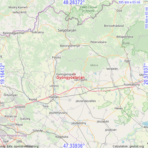
Gyöngyöstarján GPS coordinates[2]
47° 48' 49.284" North, 19° 52' 2.064" East
| Map corner | latitude | longitude |
|---|---|---|
| Upper-left | 48.28372°, | 19.16412° |
| Center: | 47.81369°, | 19.86724° |
| Lower-right: | 47.33936°, | 20.57037° |
| Map W x H: | 105×105 km | = 65.2×65.2mi |
| max Lat: | 48.46667° ⇑21.9% North |
| Gyöngyöstarján: | 47.81369° |
| min Lat: | ⇓78.1% South 45.79108° |
| min Long | Gyöngyöstarj� | max Long |
| 16.27358° | 19.86724° | 22.68096° |
| W 58.7%⇐ | ⇒41.3% E |
Elevation
Elevation of Gyöngyöstarján is 198 m = 650 ft, and this is 68.3 m = 224 ft above average elevation for this country.
| Max E: |
444 m = 1457 ft | 8.1% |
| Gyöngyöstarján | 198 m 650 ft | |
| Avg. | 129.7 m = 426 ft | |
Min E: |
71 m = 233 ft | 91.9% |
See also: Hungary elevation on elevation.city.
Geographical zone
Gyöngyöstarján is located in North temperate zone (between Tropic of Cancer and the Arctic Circle). Distance of this North polar circle is 2084.8 km =1295.4 mi to North.| Distance of | km | miles | from Gyöngyöstarján |
|---|---|---|---|
| North Pole | 4690.7 | 2914.7 | to North |
| Arctic Circle | 2084.8 | 1295.4 | to North |
| Tropic Cancer | 2710.5 | 1684.2 | to South |
| Equator | 5316.4 | 3303.5 | to South |


Nearby cities:
15 places around Gyöngyöstarján: (largest is in red/bold)
• Abasár
10.3 km =6.4 mi,  100°
100°
• Apc
13.1 km =8.1 mi,  260°
260°
• Ecséd
11.7 km =7.3 mi,  219°
219°
• Gyöngyös
5.7 km =3.5 mi,  127°
127°
• Gyöngyöshalász
9.2 km =5.7 mi,  150°
150°
• Gyöngyöspata
5.8 km =3.6 mi,  271°
271°
• Gyöngyössolymos
5.2 km =3.2 mi,  85°
85°
• Hort
14.9 km =9.3 mi,  203°
203°
• Jobbágyi
14.3 km =8.9 mi,  278°
278°
• Nagyréde
5.6 km =3.5 mi,  194°
194°
• Parádsasvár
13.7 km =8.5 mi,  36°
36°
• Petőfibánya
13.4 km =8.3 mi,  248°
248°
• Rózsaszentmárton
10 km =6.2 mi, 249°
• Szurdokpüspöki
14 km =8.7 mi,  291°
291°
• Vámosgyörk
15.1 km =9.4 mi,  162°
162°
Sources, notices
• [Note1] Compared only with cities in Hungary existing in our database
• [Src1] Map data: © OpenStreetMap contributors (CC-BY-SA)
• [Src2] Other city data from geonames.org with taken over terms of usage.
• [Src3] Geographical zone / Annual Mean Temperature by Robert A. Rohde @ Wikipedia
