Nagyréde geodata
Nagyréde (Heves) is a populated place; located in Hungary in Europe/Budapest (GMT+2) time zone. With population of 3,308 people, there are 442 cities with bigger population in this country. Compared to other cities in Hungary, 74.9% of cities are located further ↓South; 58.3% of cities are located further ←West and 66.9% of cities have lower elevation than Nagyréde. Note1


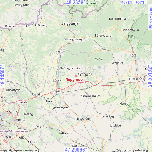
Nagyréde GPS coordinates[2]
47° 45' 55.548" North, 19° 50' 53.484" East
| Map corner | latitude | longitude |
|---|---|---|
| Upper-left | 48.2359°, | 19.14507° |
| Center: | 47.76543°, | 19.84819° |
| Lower-right: | 47.29066°, | 20.55132° |
| Map W x H: | 105.1×105.1 km | = 65.3×65.3mi |
| max Lat: | 48.46667° ⇑25.1% North |
| Nagyréde: | 47.76543° |
| min Lat: | ⇓74.9% South 45.79108° |
| min Long | Nagyréde | max Long |
| 16.27358° | 19.84819° | 22.68096° |
| W 58.3%⇐ | ⇒41.7% E |
Elevation
Elevation of Nagyréde is 133 m = 436 ft, and this is 3.3 m = 11 ft above average elevation for this country.
| Max E: |
444 m = 1457 ft | 33.1% |
| Nagyréde | 133 m 436 ft | |
| Avg. | 129.7 m = 426 ft | |
Min E: |
71 m = 233 ft | 66.9% |
See also: Hungary elevation on elevation.city.
Geographical zone
Nagyréde is located in North temperate zone (between Tropic of Cancer and the Arctic Circle). Distance of this North polar circle is 2090.2 km =1298.8 mi to North.| Distance of | km | miles | from Nagyréde |
|---|---|---|---|
| North Pole | 4696 | 2918 | to North |
| Arctic Circle | 2090.2 | 1298.8 | to North |
| Tropic Cancer | 2705.1 | 1680.9 | to South |
| Equator | 5311 | 3300.1 | to South |


Nearby cities:
15 places around Nagyréde: (largest is in red/bold)
• Abasár
12.1 km =7.5 mi,  73°
73°
• Adács
12.6 km =7.8 mi,  130°
130°
• Apc
11.9 km =7.4 mi,  285°
285°
• Csány
13.1 km =8.1 mi,  186°
186°
• Ecséd
7.1 km =4.4 mi,  239°
239°
• Gyöngyös
6.3 km =3.9 mi, 72°
• Gyöngyöshalász
6.6 km =4.1 mi,  113°
113°
• Gyöngyöspata
7.1 km =4.4 mi,  321°
321°
• Gyöngyössolymos
8.7 km =5.4 mi,  48°
48°
• Gyöngyöstarján
5.6 km =3.5 mi,  14°
14°
• Hort
9.4 km =5.8 mi,  207°
207°
• Lőrinci
13.2 km =8.2 mi,  254°
254°
• Petőfibánya
11.1 km =6.9 mi,  272°
272°
• Rózsaszentmárton
8.1 km =5 mi,  283°
283°
• Vámosgyörk
10.9 km =6.8 mi,  146°
146°
Sources, notices
• [Note1] Compared only with cities in Hungary existing in our database
• [Src1] Map data: © OpenStreetMap contributors (CC-BY-SA)
• [Src2] Other city data from geonames.org with taken over terms of usage.
• [Src3] Geographical zone / Annual Mean Temperature by Robert A. Rohde @ Wikipedia
