Nagymaros geodata
Nagymaros (Pest) is a populated place; located in Hungary in Europe/Budapest (GMT+2) time zone. With population of 4,629 people, there are 321 cities with bigger population in this country. Compared to other cities in Hungary, 76.8% of cities are located further ↓South; 66% of cities are located further →East and 63.9% of cities have higher elevation than Nagymaros. Note1


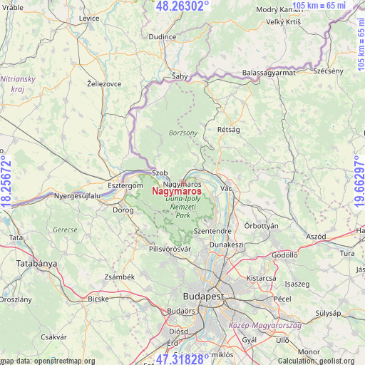
Nagymaros GPS coordinates[2]
47° 47' 34.08" North, 18° 57' 35.424" East
| Map corner | latitude | longitude |
|---|---|---|
| Upper-left | 48.26302°, | 18.25672° |
| Center: | 47.7928°, | 18.95984° |
| Lower-right: | 47.31828°, | 19.66297° |
| Map W x H: | 105×105 km | = 65.2×65.2mi |
| max Lat: | 48.46667° ⇑23.2% North |
| Nagymaros: | 47.7928° |
| min Lat: | ⇓76.8% South 45.79108° |
| min Long | Nagymaros | max Long |
| 16.27358° | 18.95984° | 22.68096° |
| W 34%⇐ | ⇒66% E |
Elevation
Elevation of Nagymaros is 107 m = 351 ft, and this is 22.7 m = 74 ft below average elevation for this country.
| Max E: |
444 m = 1457 ft | 63.9% |
| Avg. | 129.7 m = 426 ft | |
| Nagymaros | 107 m = 351 ft | |
Min E: |
71 m = 233 ft | 36.1% |
See also: Hungary elevation on elevation.city.
Geographical zone
Nagymaros is located in North temperate zone (between Tropic of Cancer and the Arctic Circle). Distance of this North polar circle is 2087.1 km =1296.9 mi to North.| Distance of | km | miles | from Nagymaros |
|---|---|---|---|
| North Pole | 4693 | 2916.1 | to North |
| Arctic Circle | 2087.1 | 1296.9 | to North |
| Tropic Cancer | 2708.1 | 1682.7 | to South |
| Equator | 5314.1 | 3302 | to South |


Nearby cities:
15 places around Nagymaros: (largest is in red/bold)
• Csobánka
16.3 km =10.1 mi,  179°
179°
• Dunabogdány
6.1 km =3.8 mi,  92°
92°
• Kesztölc
14.8 km =9.2 mi,  232°
232°
• Kismaros
6 km =3.7 mi,  33°
33°
• Leányfalu
12.6 km =7.8 mi,  131°
131°
• Pilismarót
6.4 km =4 mi,  261°
261°
• Pilisszentkereszt
12 km =7.5 mi,  199°
199°
• Pilisszántó
14.8 km =9.2 mi, 201°
• Szentendre
16.2 km =10.1 mi,  147°
147°
• Szob
7.3 km =4.5 mi,  293°
293°
• Sződliget
15.5 km =9.6 mi,  115°
115°
• Tahitótfalu
11.5 km =7.1 mi,  114°
114°
• Verőce
6.6 km =4.1 mi,  57°
57°
• Visegrád
1.2 km =0.7 mi,  135°
135°
• Vác
13.3 km =8.3 mi,  98°
98°
Sources, notices
• [Note1] Compared only with cities in Hungary existing in our database
• [Src1] Map data: © OpenStreetMap contributors (CC-BY-SA)
• [Src2] Other city data from geonames.org with taken over terms of usage.
• [Src3] Geographical zone / Annual Mean Temperature by Robert A. Rohde @ Wikipedia
