Paks geodata
Paks (Tolna) is a seat of a second-order administrative division; located in Hungary in Europe/Budapest (GMT+2) time zone. With population of 20,638 people, there are 83 cities with bigger population in this country. Compared to other cities in Hungary, 82.7% of cities are located further ↑North; 69.4% of cities are located further →East and 100% of cities have higher elevation than Paks. Note1


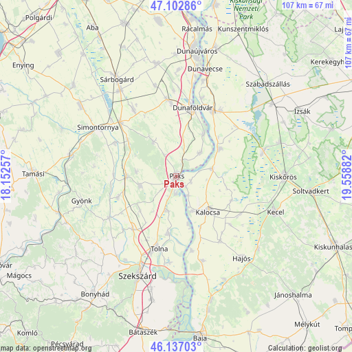
Paks GPS coordinates[2]
46° 37' 19.56" North, 18° 51' 20.484" East
| Map corner | latitude | longitude |
|---|---|---|
| Upper-left | 47.10286°, | 18.15257° |
| Center: | 46.6221°, | 18.85569° |
| Lower-right: | 46.13703°, | 19.55882° |
| Map W x H: | 107.4×107.4 km | = 66.7×66.7mi |
| max Lat: | 48.46667° ⇑82.7% North |
| Paks: | 46.6221° |
| min Lat: | ⇓17.3% South 45.79108° |
| min Long | Paks | max Long |
| 16.27358° | 18.85569° | 22.68096° |
| W 30.6%⇐ | ⇒69.4% E |
Elevation
Elevation of Paks is 71 m = 233 ft, and this is 58.7 m = 193 ft below average elevation for this country.
| Max E: |
444 m = 1457 ft | 100% |
| Avg. | 129.7 m = 426 ft | |
| Paks | 71 m = 233 ft | |
Min E: |
71 m = 233 ft | 0% |
See also: Hungary elevation on elevation.city.
Geographical zone
Paks is located in North temperate zone (between Tropic of Cancer and the Arctic Circle). Distance of this North polar circle is 2217.3 km =1377.8 mi to North.| Distance of | km | miles | from Paks |
|---|---|---|---|
| North Pole | 4823.2 | 2997 | to North |
| Arctic Circle | 2217.3 | 1377.8 | to North |
| Tropic Cancer | 2578 | 1601.9 | to South |
| Equator | 5183.9 | 3221.1 | to South |


Nearby cities:
15 places around Paks: (largest is in red/bold)
• Bátya
16.7 km =10.4 mi,  153°
153°
• Bölcske
15.7 km =9.8 mi,  32°
32°
• Dunaföldvár
21.3 km =13.2 mi,  14°
14°
• Dunapataj
11 km =6.8 mi,  77°
77°
• Dunaszentgyörgy
10.8 km =6.7 mi,  195°
195°
• Fadd
17.7 km =11 mi,  189°
189°
• Harta
15.8 km =9.8 mi,  57°
57°
• Kalocsa
13.6 km =8.5 mi,  138°
138°
• Madocsa
10.7 km =6.6 mi,  46°
46°
• Nagydorog
15.3 km =9.5 mi,  272°
272°
• Németkér
12.6 km =7.8 mi,  326°
326°
• Solt
22.8 km =14.2 mi, 29°
• Szedres
21 km =13 mi,  219°
219°
• Tengelic
15.2 km =9.4 mi,  226°
226°
• Tolna
22.4 km =13.9 mi, 194°
Sources, notices
• [Note1] Compared only with cities in Hungary existing in our database
• [Src1] Map data: © OpenStreetMap contributors (CC-BY-SA)
• [Src2] Other city data from geonames.org with taken over terms of usage.
• [Src3] Geographical zone / Annual Mean Temperature by Robert A. Rohde @ Wikipedia
