Fadd geodata
Fadd (Tolna) is a populated place; located in Hungary in Europe/Budapest (GMT+2) time zone. With population of 4,442 people, there are 336 cities with bigger population in this country. Compared to other cities in Hungary, 86.9% of cities are located further ↑North; 70.5% of cities are located further →East and 80.4% of cities have higher elevation than Fadd. Note1


Fadd GPS coordinates[2]
46° 27' 53.136" North, 18° 49' 9.3" East
| Map corner | latitude | longitude |
|---|---|---|
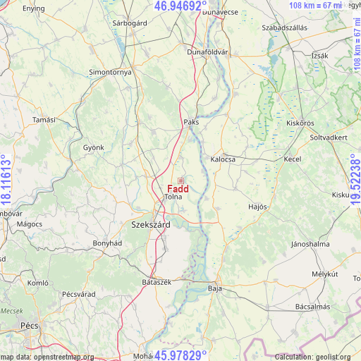
| Upper-left | 46.94692°, | 18.11613° |
| Center: | 46.46476°, | 18.81925° |
| Lower-right: | 45.97829°, | 19.52238° |
| Map W x H: | 107.7×107.7 km | = 66.9×66.9mi |
| max Lat: | 48.46667° ⇑86.9% North |
| Fadd: | 46.46476° |
| min Lat: | ⇓13.1% South 45.79108° |
| min Long | Fadd | max Long |
| 16.27358° | 18.81925° | 22.68096° |
| W 29.5%⇐ | ⇒70.5% E |
Elevation
Elevation of Fadd is 95 m = 312 ft, and this is 34.7 m = 114 ft below average elevation for this country.
| Max E: |
444 m = 1457 ft | 80.4% |
| Avg. | 129.7 m = 426 ft | |
| Fadd | 95 m = 312 ft | |
Min E: |
71 m = 233 ft | 19.6% |
See also: Hungary elevation on elevation.city.
Geographical zone
Fadd is located in North temperate zone (between Tropic of Cancer and the Arctic Circle). Distance of this North polar circle is 2234.8 km =1388.6 mi to North.| Distance of | km | miles | from Fadd |
|---|---|---|---|
| North Pole | 4840.7 | 3007.9 | to North |
| Arctic Circle | 2234.8 | 1388.6 | to North |
| Tropic Cancer | 2560.5 | 1591 | to South |
| Equator | 5166.4 | 3210.3 | to South |


Nearby cities:
15 places around Fadd: (largest is in red/bold)
• Bogyiszló
8.8 km =5.5 mi,  174°
174°
• Bátya
10.7 km =6.6 mi,  75°
75°
• Decs
20.6 km =12.8 mi,  192°
192°
• Dunaszentgyörgy
7.1 km =4.4 mi,  359°
359°
• Dusnok
13.7 km =8.5 mi,  126°
126°
• Kalocsa
13.8 km =8.6 mi,  58°
58°
• Nagydorog
22 km =13.7 mi,  325°
325°
• Paks
17.7 km =11 mi,  9°
9°
• Szedres
10.5 km =6.5 mi,  276°
276°
• Szekszárd
15.3 km =9.5 mi,  213°
213°
• Szentgálpuszta
17.9 km =11.1 mi,  235°
235°
• Tengelic
10.9 km =6.8 mi,  310°
310°
• Tolna
5.1 km =3.2 mi, 213°
• Zomba
20.3 km =12.6 mi,  252°
252°
• Őcsény
17.5 km =10.9 mi,  195°
195°
Sources, notices
• [Note1] Compared only with cities in Hungary existing in our database
• [Src1] Map data: © OpenStreetMap contributors (CC-BY-SA)
• [Src2] Other city data from geonames.org with taken over terms of usage.
• [Src3] Geographical zone / Annual Mean Temperature by Robert A. Rohde @ Wikipedia
