Tolna geodata
Tolna is a seat of a second-order administrative division; located in Hungary in Europe/Budapest (GMT+2) time zone. With population of 12,011 people, there are 136 cities with bigger population in this country. Compared to other cities in Hungary, 87.8% of cities are located further ↑North; 71.3% of cities are located further →East and 72.5% of cities have higher elevation than Tolna. Note1


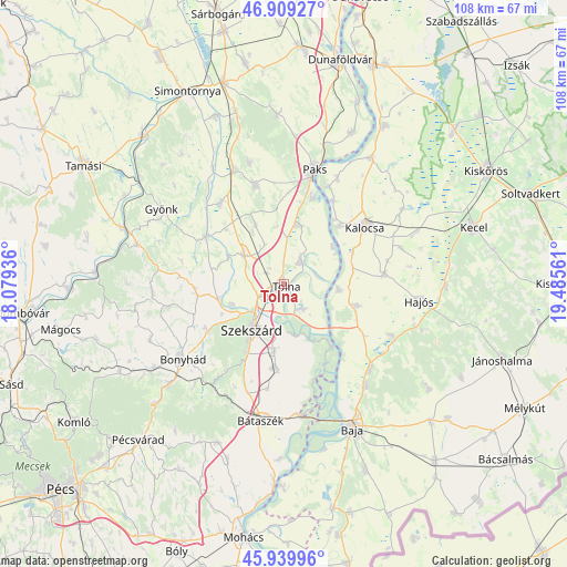
Tolna GPS coordinates[2]
46° 25' 36.372" North, 18° 46' 56.928" East
| Map corner | latitude | longitude |
|---|---|---|
| Upper-left | 46.90927°, | 18.07936° |
| Center: | 46.42677°, | 18.78248° |
| Lower-right: | 45.93996°, | 19.48561° |
| Map W x H: | 107.8×107.8 km | = 67×67mi |
| max Lat: | 48.46667° ⇑87.8% North |
| Tolna: | 46.42677° |
| min Lat: | ⇓12.2% South 45.79108° |
| min Long | Tolna | max Long |
| 16.27358° | 18.78248° | 22.68096° |
| W 28.7%⇐ | ⇒71.3% E |
Elevation
Elevation of Tolna is 100 m = 328 ft, and this is 29.7 m = 97 ft below average elevation for this country.
| Max E: |
444 m = 1457 ft | 72.5% |
| Avg. | 129.7 m = 426 ft | |
| Tolna | 100 m = 328 ft | |
Min E: |
71 m = 233 ft | 27.5% |
See also: Hungary elevation on elevation.city.
Geographical zone
Tolna is located in North temperate zone (between Tropic of Cancer and the Arctic Circle). Distance of this North polar circle is 2239 km =1391.2 mi to North.| Distance of | km | miles | from Tolna |
|---|---|---|---|
| North Pole | 4844.9 | 3010.5 | to North |
| Arctic Circle | 2239 | 1391.2 | to North |
| Tropic Cancer | 2556.3 | 1588.4 | to South |
| Equator | 5162.2 | 3207.6 | to South |


Nearby cities:
15 places around Tolna: (largest is in red/bold)
• Bogyiszló
5.8 km =3.6 mi,  141°
141°
• Bátya
14.8 km =9.2 mi,  62°
62°
• Decs
15.9 km =9.9 mi,  186°
186°
• Dunaszentgyörgy
11.6 km =7.2 mi,  13°
13°
• Dusnok
14.4 km =8.9 mi,  106°
106°
• Fadd
5.1 km =3.2 mi,  33°
33°
• Kalocsa
18.5 km =11.5 mi,  51°
51°
• Nemesnádudvar
22.7 km =14.1 mi, 114°
• Paks
22.4 km =13.9 mi, 14°
• Szedres
9.3 km =5.8 mi,  305°
305°
• Szekszárd
10.2 km =6.3 mi,  213°
213°
• Szentgálpuszta
13.3 km =8.3 mi,  244°
244°
• Tengelic
12.6 km =7.8 mi,  334°
334°
• Zomba
16.7 km =10.4 mi,  263°
263°
• Őcsény
12.7 km =7.9 mi, 188°
Sources, notices
• [Note1] Compared only with cities in Hungary existing in our database
• [Src1] Map data: © OpenStreetMap contributors (CC-BY-SA)
• [Src2] Other city data from geonames.org with taken over terms of usage.
• [Src3] Geographical zone / Annual Mean Temperature by Robert A. Rohde @ Wikipedia
