Dunaszentgyörgy geodata
Dunaszentgyörgy (Tolna) is a populated place; located in Hungary in Europe/Budapest (GMT+2) time zone. With population of 2,624 people, there are 591 cities with bigger population in this country. Compared to other cities in Hungary, 85.6% of cities are located further ↑North; 70.8% of cities are located further →East and 74.5% of cities have higher elevation than Dunaszentgyörgy. Note1


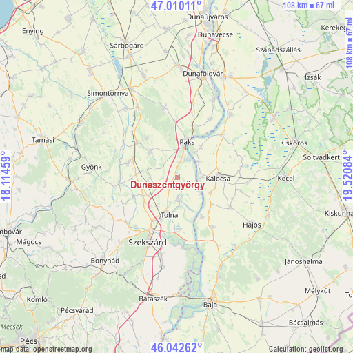
Dunaszentgyörgy GPS coordinates[2]
46° 31' 42.672" North, 18° 49' 3.756" East
| Map corner | latitude | longitude |
|---|---|---|
| Upper-left | 47.01011°, | 18.11459° |
| Center: | 46.52852°, | 18.81771° |
| Lower-right: | 46.04262°, | 19.52084° |
| Map W x H: | 107.6×107.6 km | = 66.9×66.9mi |
| max Lat: | 48.46667° ⇑85.6% North |
| Dunaszentgyörgy: | 46.52852° |
| min Lat: | ⇓14.4% South 45.79108° |
| min Long | Dunaszentgyörg | max Long |
| 16.27358° | 18.81771° | 22.68096° |
| W 29.2%⇐ | ⇒70.8% E |
Elevation
Elevation of Dunaszentgyörgy is 99 m = 325 ft, and this is 30.7 m = 101 ft below average elevation for this country.
| Max E: |
444 m = 1457 ft | 74.5% |
| Avg. | 129.7 m = 426 ft | |
| Dunaszentgyörgy | 99 m = 325 ft | |
Min E: |
71 m = 233 ft | 25.5% |
See also: Hungary elevation on elevation.city.
Geographical zone
Dunaszentgyörgy is located in North temperate zone (between Tropic of Cancer and the Arctic Circle). Distance of this North polar circle is 2227.7 km =1384.2 mi to North.| Distance of | km | miles | from Dunaszentgyörgy |
|---|---|---|---|
| North Pole | 4833.6 | 3003.5 | to North |
| Arctic Circle | 2227.7 | 1384.2 | to North |
| Tropic Cancer | 2567.6 | 1595.4 | to South |
| Equator | 5173.5 | 3214.7 | to South |


Nearby cities:
15 places around Dunaszentgyörgy: (largest is in red/bold)
• Bogyiszló
15.8 km =9.8 mi,  176°
176°
• Bátya
11.4 km =7.1 mi,  113°
113°
• Dunapataj
18.7 km =11.6 mi,  46°
46°
• Dusnok
18.9 km =11.7 mi,  143°
143°
• Fadd
7.1 km =4.4 mi, 179°
• Kalocsa
11.9 km =7.4 mi,  89°
89°
• Madocsa
20.7 km =12.9 mi,  31°
31°
• Nagydorog
16.6 km =10.3 mi,  311°
311°
• Németkér
21.3 km =13.2 mi,  348°
348°
• Paks
10.8 km =6.7 mi,  15°
15°
• Szedres
11.9 km =7.4 mi,  240°
240°
• Szekszárd
21.5 km =13.4 mi,  202°
202°
• Szentgálpuszta
22.5 km =14 mi,  220°
220°
• Tengelic
8.2 km =5.1 mi,  270°
270°
• Tolna
11.6 km =7.2 mi,  193°
193°
Sources, notices
• [Note1] Compared only with cities in Hungary existing in our database
• [Src1] Map data: © OpenStreetMap contributors (CC-BY-SA)
• [Src2] Other city data from geonames.org with taken over terms of usage.
• [Src3] Geographical zone / Annual Mean Temperature by Robert A. Rohde @ Wikipedia
