Nyárlőrinc geodata
Nyárlőrinc (Bács-Kiskun) is a populated place; located in Hungary in Europe/Budapest (GMT+2) time zone. With population of 2,384 people, there are 642 cities with bigger population in this country. Compared to other cities in Hungary, 74.4% of cities are located further ↑North; 58.9% of cities are located further ←West and 69.7% of cities have higher elevation than Nyárlőrinc. Note1


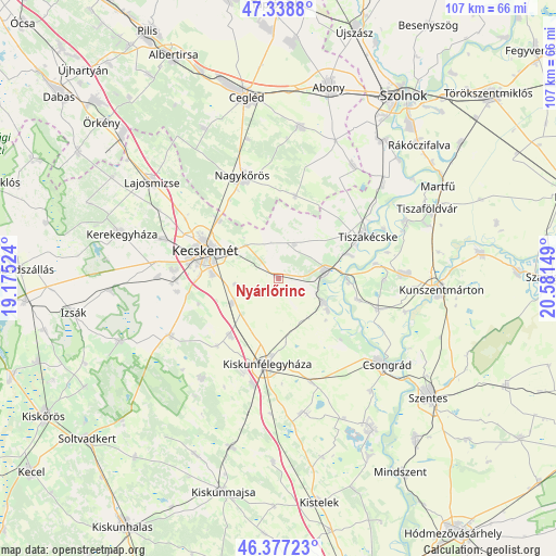
Nyárlőrinc GPS coordinates[2]
46° 51' 36.612" North, 19° 52' 42.096" East
| Map corner | latitude | longitude |
|---|---|---|
| Upper-left | 47.3388°, | 19.17524° |
| Center: | 46.86017°, | 19.87836° |
| Lower-right: | 46.37723°, | 20.58149° |
| Map W x H: | 106.9×106.9 km | = 66.4×66.4mi |
| max Lat: | 48.46667° ⇑74.4% North |
| Nyárlőrinc: | 46.86017° |
| min Lat: | ⇓25.6% South 45.79108° |
| min Long | Nyárlőrinc | max Long |
| 16.27358° | 19.87836° | 22.68096° |
| W 58.9%⇐ | ⇒41.1% E |
Elevation
Elevation of Nyárlőrinc is 102 m = 335 ft, and this is 27.7 m = 91 ft below average elevation for this country.
| Max E: |
444 m = 1457 ft | 69.7% |
| Avg. | 129.7 m = 426 ft | |
| Nyárlőrinc | 102 m = 335 ft | |
Min E: |
71 m = 233 ft | 30.3% |
See also: Hungary elevation on elevation.city.
Geographical zone
Nyárlőrinc is located in North temperate zone (between Tropic of Cancer and the Arctic Circle). Distance of this North polar circle is 2190.8 km =1361.3 mi to North.| Distance of | km | miles | from Nyárlőrinc |
|---|---|---|---|
| North Pole | 4796.7 | 2980.5 | to North |
| Arctic Circle | 2190.8 | 1361.3 | to North |
| Tropic Cancer | 2604.4 | 1618.3 | to South |
| Equator | 5210.4 | 3237.6 | to South |


Nearby cities:
15 places around Nyárlőrinc: (largest is in red/bold)
• Ballószög
23.4 km =14.5 mi,  270°
270°
• Bugac
24.4 km =15.2 mi,  218°
218°
• Cserkeszőlő
23.5 km =14.6 mi,  89°
89°
• Fülöpjakab
17.7 km =11 mi, 222°
• Helvécia
19.6 km =12.2 mi,  262°
262°
• Jászkarajenő
25.5 km =15.8 mi,  34°
34°
• Kecskemét
15.1 km =9.4 mi,  289°
289°
• Kiskunfélegyháza
16.7 km =10.4 mi,  188°
188°
• Kocsér
16.1 km =10 mi,  11°
11°
• Lakitelek
9 km =5.6 mi,  78°
78°
• Nagykőrös
20.8 km =12.9 mi,  338°
338°
• Szentkirály
7.2 km =4.5 mi, 25°
• Tiszaalpár
10.5 km =6.5 mi,  119°
119°
• Tiszakécske
18.9 km =11.7 mi,  64°
64°
• Városföld
10.4 km =6.5 mi,  242°
242°
Sources, notices
• [Note1] Compared only with cities in Hungary existing in our database
• [Src1] Map data: © OpenStreetMap contributors (CC-BY-SA)
• [Src2] Other city data from geonames.org with taken over terms of usage.
• [Src3] Geographical zone / Annual Mean Temperature by Robert A. Rohde @ Wikipedia
