Lakitelek geodata
Lakitelek (Bács-Kiskun) is a populated place; located in Hungary in Europe/Budapest (GMT+2) time zone. With population of 4,435 people, there are 338 cities with bigger population in this country. Compared to other cities in Hungary, 73.5% of cities are located further ↑North; 61.7% of cities are located further ←West and 83.2% of cities have higher elevation than Lakitelek. Note1


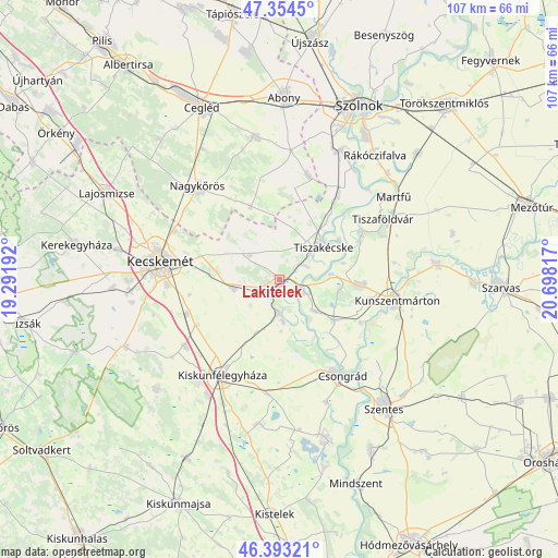
Lakitelek GPS coordinates[2]
46° 52' 33.636" North, 19° 59' 42.144" East
| Map corner | latitude | longitude |
|---|---|---|
| Upper-left | 47.3545°, | 19.29192° |
| Center: | 46.87601°, | 19.99504° |
| Lower-right: | 46.39321°, | 20.69817° |
| Map W x H: | 106.9×106.9 km | = 66.4×66.4mi |
| max Lat: | 48.46667° ⇑73.5% North |
| Lakitelek: | 46.87601° |
| min Lat: | ⇓26.5% South 45.79108° |
| min Long | Lakitelek | max Long |
| 16.27358° | 19.99504° | 22.68096° |
| W 61.7%⇐ | ⇒38.3% E |
Elevation
Elevation of Lakitelek is 92 m = 302 ft, and this is 37.7 m = 124 ft below average elevation for this country.
| Max E: |
444 m = 1457 ft | 83.2% |
| Avg. | 129.7 m = 426 ft | |
| Lakitelek | 92 m = 302 ft | |
Min E: |
71 m = 233 ft | 16.8% |
See also: Hungary elevation on elevation.city.
Geographical zone
Lakitelek is located in North temperate zone (between Tropic of Cancer and the Arctic Circle). Distance of this North polar circle is 2189.1 km =1360.2 mi to North.| Distance of | km | miles | from Lakitelek |
|---|---|---|---|
| North Pole | 4794.9 | 2979.4 | to North |
| Arctic Circle | 2189.1 | 1360.2 | to North |
| Tropic Cancer | 2606.2 | 1619.4 | to South |
| Equator | 5212.1 | 3238.6 | to South |


Nearby cities:
15 places around Lakitelek: (largest is in red/bold)
• Cibakháza
18 km =11.2 mi,  58°
58°
• Cserkeszőlő
14.7 km =9.1 mi,  95°
95°
• Csongrád
21.3 km =13.2 mi,  148°
148°
• Jászkarajenő
20.1 km =12.5 mi,  15°
15°
• Kecskemét
23.3 km =14.5 mi,  278°
278°
• Kiskunfélegyháza
21.5 km =13.4 mi,  212°
212°
• Kocsér
15.1 km =9.4 mi,  337°
337°
• Kunszentmárton
22.7 km =14.1 mi, 100°
• Nyárlőrinc
9 km =5.6 mi,  258°
258°
• Szelevény
17.8 km =11.1 mi,  117°
117°
• Szentkirály
7.5 km =4.7 mi,  309°
309°
• Tiszaalpár
7 km =4.3 mi,  177°
177°
• Tiszaföldvár
22.7 km =14.1 mi, 58°
• Tiszakécske
10.4 km =6.5 mi,  52°
52°
• Városföld
19.3 km =12 mi,  250°
250°
Sources, notices
• [Note1] Compared only with cities in Hungary existing in our database
• [Src1] Map data: © OpenStreetMap contributors (CC-BY-SA)
• [Src2] Other city data from geonames.org with taken over terms of usage.
• [Src3] Geographical zone / Annual Mean Temperature by Robert A. Rohde @ Wikipedia
