Kecskemét geodata
Kecskemét (Bács-Kiskun) is a seat of a first-order administrative division; located in Hungary in Europe/Budapest (GMT+2) time zone. With population of 109,847 people, there are 11 cities with bigger population in this country. Compared to other cities in Hungary, 72.3% of cities are located further ↑North; 54.7% of cities are located further ←West and 54.3% of cities have lower elevation than Kecskemét. Note1


Kecskemét GPS coordinates[2]
46° 54' 22.248" North, 19° 41' 28.608" East
| Map corner | latitude | longitude |
|---|---|---|
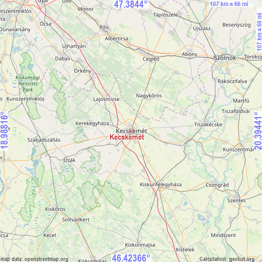
| Upper-left | 47.3844°, | 18.98816° |
| Center: | 46.90618°, | 19.69128° |
| Lower-right: | 46.42366°, | 20.39441° |
| Map W x H: | 106.8×106.8 km | = 66.4×66.4mi |
| max Lat: | 48.46667° ⇑72.3% North |
| Kecskemét: | 46.90618° |
| min Lat: | ⇓27.7% South 45.79108° |
| min Long | Kecskemét | max Long |
| 16.27358° | 19.69128° | 22.68096° |
| W 54.7%⇐ | ⇒45.3% E |
Elevation
Elevation of Kecskemét is 120 m = 394 ft, and this is 9.7 m = 32 ft below average elevation for this country.
| Max E: |
444 m = 1457 ft | 45.7% |
| Avg. | 129.7 m = 426 ft | |
| Kecskemét | 120 m = 394 ft | |
Min E: |
71 m = 233 ft | 54.3% |
See also: Kecskemét elevation on elevation.city.
Geographical zone
Kecskemét is located in North temperate zone (between Tropic of Cancer and the Arctic Circle). Distance of this North polar circle is 2185.7 km =1358.1 mi to North.| Distance of | km | miles | from Kecskemét |
|---|---|---|---|
| North Pole | 4791.6 | 2977.4 | to North |
| Arctic Circle | 2185.7 | 1358.1 | to North |
| Tropic Cancer | 2609.6 | 1621.5 | to South |
| Equator | 5215.5 | 3240.8 | to South |


Nearby cities:
15 places around Kecskemét: (largest is in red/bold)
• Ballószög
10.4 km =6.5 mi,  241°
241°
• Bugac
24.4 km =15.2 mi,  181°
181°
• Csemő
23.6 km =14.7 mi,  359°
359°
• Fülöpjakab
18.4 km =11.4 mi,  172°
172°
• Helvécia
9.3 km =5.8 mi,  214°
214°
• Kerekegyháza
16.6 km =10.3 mi,  282°
282°
• Kocsér
20.4 km =12.7 mi,  58°
58°
• Lajosmizse
16.1 km =10 mi,  322°
322°
• Lakitelek
23.3 km =14.5 mi,  98°
98°
• Nagykőrös
15.7 km =9.8 mi,  24°
24°
• Nyárlőrinc
15.1 km =9.4 mi,  109°
109°
• Orgovány
24 km =14.9 mi,  223°
223°
• Szentkirály
17.3 km =10.7 mi,  85°
85°
• Városföld
11.1 km =6.9 mi,  153°
153°
• Ágasegyháza
19.6 km =12.2 mi,  248°
248°
Sources, notices
• [Note1] Compared only with cities in Hungary existing in our database
• [Src1] Map data: © OpenStreetMap contributors (CC-BY-SA)
• [Src2] Other city data from geonames.org with taken over terms of usage.
• [Src3] Geographical zone / Annual Mean Temperature by Robert A. Rohde @ Wikipedia
