Érsekcsanád geodata
Érsekcsanád (Bács-Kiskun) is a populated place; located in Hungary in Europe/Budapest (GMT+2) time zone. With population of 2,863 people, there are 521 cities with bigger population in this country. Compared to other cities in Hungary, 93.7% of cities are located further ↑North; 64.8% of cities are located further →East and 78.9% of cities have higher elevation than Érsekcsanád. Note1


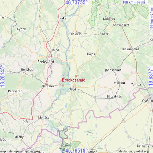
Érsekcsanád GPS coordinates[2]
46° 15' 12.672" North, 18° 59' 4.452" East
| Map corner | latitude | longitude |
|---|---|---|
| Upper-left | 46.73755°, | 18.28145° |
| Center: | 46.25352°, | 18.98457° |
| Lower-right: | 45.76518°, | 19.6877° |
| Map W x H: | 108.1×108.1 km | = 67.2×67.2mi |
| max Lat: | 48.46667° ⇑93.7% North |
| Érsekcsanád: | 46.25352° |
| min Lat: | ⇓6.3% South 45.79108° |
| min Long | Érsekcsanád | max Long |
| 16.27358° | 18.98457° | 22.68096° |
| W 35.2%⇐ | ⇒64.8% E |
Elevation
Elevation of Érsekcsanád is 96 m = 315 ft, and this is 33.7 m = 111 ft below average elevation for this country.
| Max E: |
444 m = 1457 ft | 78.9% |
| Avg. | 129.7 m = 426 ft | |
| Érsekcsanád | 96 m = 315 ft | |
Min E: |
71 m = 233 ft | 21.1% |
See also: Hungary elevation on elevation.city.
Geographical zone
Érsekcsanád is located in North temperate zone (between Tropic of Cancer and the Arctic Circle). Distance of this North polar circle is 2258.3 km =1403.2 mi to North.| Distance of | km | miles | from Érsekcsanád |
|---|---|---|---|
| North Pole | 4864.2 | 3022.5 | to North |
| Arctic Circle | 2258.3 | 1403.2 | to North |
| Tropic Cancer | 2537 | 1576.4 | to South |
| Equator | 5142.9 | 3195.6 | to South |


Nearby cities:
15 places around Érsekcsanád: (largest is in red/bold)
• Baja
8.2 km =5.1 mi,  197°
197°
• Bogyiszló
19 km =11.8 mi,  321°
321°
• Bácsbokod
19.5 km =12.1 mi,  137°
137°
• Báta
21.6 km =13.4 mi,  229°
229°
• Bátaszék
21.2 km =13.2 mi,  251°
251°
• Csávoly
14.4 km =8.9 mi,  119°
119°
• Decs
17.6 km =10.9 mi,  281°
281°
• Dusnok
15.4 km =9.6 mi,  353°
353°
• Felsőszentiván
16.8 km =10.4 mi,  111°
111°
• Hajós
19.2 km =11.9 mi,  32°
32°
• Nemesnádudvar
10.9 km =6.8 mi, 27°
• Szekszárd
23.7 km =14.7 mi,  296°
296°
• Sükösd
3.3 km =2.1 mi,  14°
14°
• Vaskút
16.2 km =10.1 mi,  179°
179°
• Őcsény
18.7 km =11.6 mi,  290°
290°
Sources, notices
• [Note1] Compared only with cities in Hungary existing in our database
• [Src1] Map data: © OpenStreetMap contributors (CC-BY-SA)
• [Src2] Other city data from geonames.org with taken over terms of usage.
• [Src3] Geographical zone / Annual Mean Temperature by Robert A. Rohde @ Wikipedia
