Csávoly geodata
Csávoly (Bács-Kiskun) is a populated place; located in Hungary in Europe/Budapest (GMT+2) time zone. With population of 2,080 people, there are 747 cities with bigger population in this country. Compared to other cities in Hungary, 96.1% of cities are located further ↑North; 58.3% of cities are located further →East and 64% of cities have lower elevation than Csávoly. Note1


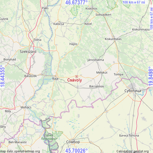
Csávoly GPS coordinates[2]
46° 11' 21.012" North, 19° 8' 48.012" East
| Map corner | latitude | longitude |
|---|---|---|
| Upper-left | 46.67377°, | 18.44355° |
| Center: | 46.18917°, | 19.14667° |
| Lower-right: | 45.70026°, | 19.8498° |
| Map W x H: | 108.2×108.2 km | = 67.2×67.2mi |
| max Lat: | 48.46667° ⇑96.1% North |
| Csávoly: | 46.18917° |
| min Lat: | ⇓3.9% South 45.79108° |
| min Long | Csávoly | max Long |
| 16.27358° | 19.14667° | 22.68096° |
| W 41.7%⇐ | ⇒58.3% E |
Elevation
Elevation of Csávoly is 130 m = 427 ft, and this is 0.30000000000001 m = 1 ft above average elevation for this country.
| Max E: |
444 m = 1457 ft | 36% |
| Csávoly | 130 m 427 ft | |
| Avg. | 129.7 m = 426 ft | |
Min E: |
71 m = 233 ft | 64% |
See also: Hungary elevation on elevation.city.
Geographical zone
Csávoly is located in North temperate zone (between Tropic of Cancer and the Arctic Circle). Distance of this North polar circle is 2265.4 km =1407.7 mi to North.| Distance of | km | miles | from Csávoly |
|---|---|---|---|
| North Pole | 4871.3 | 3026.9 | to North |
| Arctic Circle | 2265.4 | 1407.7 | to North |
| Tropic Cancer | 2529.8 | 1571.9 | to South |
| Equator | 5135.8 | 3191.2 | to South |


Nearby cities:
15 places around Csávoly: (largest is in red/bold)
• Baja
14.9 km =9.3 mi,  267°
267°
• Bácsalmás
15.9 km =9.9 mi,  115°
115°
• Bácsbokod
7.2 km =4.5 mi,  174°
174°
• Felsőszentiván
3.2 km =2 mi,  74°
74°
• Gara
19.2 km =11.9 mi,  204°
204°
• Hajós
23.4 km =14.5 mi,  355°
355°
• Jánoshalma
18.4 km =11.4 mi,  48°
48°
• Katymár
17.9 km =11.1 mi,  164°
164°
• Madaras
17 km =10.6 mi,  148°
148°
• Mélykút
18.3 km =11.4 mi,  80°
80°
• Nagybaracska
24.7 km =15.3 mi,  228°
228°
• Nemesnádudvar
18.4 km =11.4 mi,  336°
336°
• Sükösd
15.5 km =9.6 mi,  311°
311°
• Vaskút
15.4 km =9.6 mi, 233°
• Érsekcsanád
14.4 km =8.9 mi,  299°
299°
Sources, notices
• [Note1] Compared only with cities in Hungary existing in our database
• [Src1] Map data: © OpenStreetMap contributors (CC-BY-SA)
• [Src2] Other city data from geonames.org with taken over terms of usage.
• [Src3] Geographical zone / Annual Mean Temperature by Robert A. Rohde @ Wikipedia
