Bugac geodata
Bugac (Bács-Kiskun) is a populated place; located in Hungary in Europe/Budapest (GMT+2) time zone. With population of 3,066 people, there are 482 cities with bigger population in this country. Compared to other cities in Hungary, 80.9% of cities are located further ↑North; 54.1% of cities are located further ←West and 58.1% of cities have higher elevation than Bugac. Note1


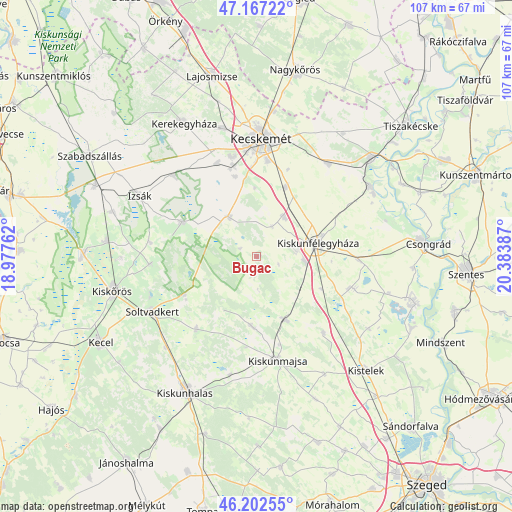
Bugac GPS coordinates[2]
46° 41' 13.344" North, 19° 40' 50.664" East
| Map corner | latitude | longitude |
|---|---|---|
| Upper-left | 47.16722°, | 18.97762° |
| Center: | 46.68704°, | 19.68074° |
| Lower-right: | 46.20255°, | 20.38387° |
| Map W x H: | 107.3×107.3 km | = 66.7×66.7mi |
| max Lat: | 48.46667° ⇑80.9% North |
| Bugac: | 46.68704° |
| min Lat: | ⇓19.1% South 45.79108° |
| min Long | Bugac | max Long |
| 16.27358° | 19.68074° | 22.68096° |
| W 54.1%⇐ | ⇒45.9% E |
Elevation
Elevation of Bugac is 111 m = 364 ft, and this is 18.7 m = 61 ft below average elevation for this country.
| Max E: |
444 m = 1457 ft | 58.1% |
| Avg. | 129.7 m = 426 ft | |
| Bugac | 111 m = 364 ft | |
Min E: |
71 m = 233 ft | 41.9% |
See also: Hungary elevation on elevation.city.
Geographical zone
Bugac is located in North temperate zone (between Tropic of Cancer and the Arctic Circle). Distance of this North polar circle is 2210.1 km =1373.3 mi to North.| Distance of | km | miles | from Bugac |
|---|---|---|---|
| North Pole | 4815.9 | 2992.5 | to North |
| Arctic Circle | 2210.1 | 1373.3 | to North |
| Tropic Cancer | 2585.2 | 1606.4 | to South |
| Equator | 5191.1 | 3225.6 | to South |


Nearby cities:
15 places around Bugac: (largest is in red/bold)
• Ballószög
21.2 km =13.2 mi,  336°
336°
• Csengele
21.3 km =13.2 mi,  139°
139°
• Fülöpjakab
6.9 km =4.3 mi,  26°
26°
• Helvécia
17.2 km =10.7 mi,  345°
345°
• Jászszentlászló
14.7 km =9.1 mi,  155°
155°
• Kecskemét
24.4 km =15.2 mi,  1°
1°
• Kiskunfélegyháza
12.8 km =8 mi,  77°
77°
• Kiskunmajsa
22.3 km =13.9 mi,  168°
168°
• Nyárlőrinc
24.4 km =15.2 mi,  38°
38°
• Orgovány
17.4 km =10.8 mi,  294°
294°
• Pálmonostora
21.8 km =13.5 mi,  108°
108°
• Szank
14.5 km =9 mi,  185°
185°
• Tázlár
20 km =12.4 mi,  219°
219°
• Városföld
15.5 km =9.6 mi,  21°
21°
• Ágasegyháza
24.4 km =15.2 mi,  314°
314°
Sources, notices
• [Note1] Compared only with cities in Hungary existing in our database
• [Src1] Map data: © OpenStreetMap contributors (CC-BY-SA)
• [Src2] Other city data from geonames.org with taken over terms of usage.
• [Src3] Geographical zone / Annual Mean Temperature by Robert A. Rohde @ Wikipedia
