Türje geodata
Türje (Zala) is a populated place; located in Hungary in Europe/Budapest (GMT+2) time zone. With population of 1,868 people, there are 841 cities with bigger population in this country. Compared to other cities in Hungary, 69.7% of cities are located further ↑North; 96.2% of cities are located further →East and 72.6% of cities have lower elevation than Türje. Note1


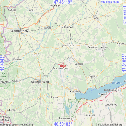
Türje GPS coordinates[2]
46° 59' 1.176" North, 17° 6' 26.712" East
| Map corner | latitude | longitude |
|---|---|---|
| Upper-left | 47.46119°, | 16.4043° |
| Center: | 46.98366°, | 17.10742° |
| Lower-right: | 46.50183°, | 17.81055° |
| Map W x H: | 106.7×106.7 km | = 66.3×66.3mi |
| max Lat: | 48.46667° ⇑69.7% North |
| Türje: | 46.98366° |
| min Lat: | ⇓30.3% South 45.79108° |
| min Long | Türje | max Long |
| 16.27358° | 17.10742° | 22.68096° |
| W 3.8%⇐ | ⇒96.2% E |
Elevation
Elevation of Türje is 141 m = 463 ft, and this is 11.3 m = 37 ft above average elevation for this country.
| Max E: |
444 m = 1457 ft | 27.4% |
| Türje | 141 m 463 ft | |
| Avg. | 129.7 m = 426 ft | |
Min E: |
71 m = 233 ft | 72.6% |
See also: Hungary elevation on elevation.city.
Geographical zone
Türje is located in North temperate zone (between Tropic of Cancer and the Arctic Circle). Distance of this North polar circle is 2177.1 km =1352.8 mi to North.| Distance of | km | miles | from Türje |
|---|---|---|---|
| North Pole | 4783 | 2972 | to North |
| Arctic Circle | 2177.1 | 1352.8 | to North |
| Tropic Cancer | 2618.2 | 1626.9 | to South |
| Equator | 5224.1 | 3246.1 | to South |


Nearby cities:
15 places around Türje: (largest is in red/bold)
• Alsóújlak
22 km =13.7 mi,  299°
299°
• Csabrendek
14.3 km =8.9 mi,  76°
76°
• Cserszegtomaj
22 km =13.7 mi,  156°
156°
• Devecser
28.4 km =17.6 mi,  62°
62°
• Gyenesdiás
27.3 km =17 mi,  150°
150°
• Hévíz
22.3 km =13.9 mi, 164°
• Jánosháza
15.7 km =9.8 mi,  16°
16°
• Keszthely
26.1 km =16.2 mi, 156°
• Nemesbük
18.8 km =11.7 mi,  170°
170°
• Sümeg
13.3 km =8.3 mi,  93°
93°
• Tapolca
27.8 km =17.3 mi,  114°
114°
• Vasvár
24.5 km =15.2 mi,  287°
287°
• Vonyarcvashegy
29.6 km =18.4 mi, 148°
• Zalaegerszeg
25.6 km =15.9 mi,  231°
231°
• Zalaszentgrót
4.8 km =3 mi,  206°
206°
Sources, notices
• [Note1] Compared only with cities in Hungary existing in our database
• [Src1] Map data: © OpenStreetMap contributors (CC-BY-SA)
• [Src2] Other city data from geonames.org with taken over terms of usage.
• [Src3] Geographical zone / Annual Mean Temperature by Robert A. Rohde @ Wikipedia
